 Scoop has an Ethical Paywall


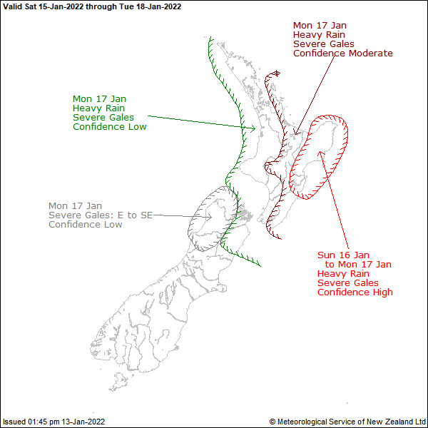
Severe Weather Outlook For New Zealand
Issued 01:45pm Thursday 13 Jan 2022
Valid from
Saturday 15 Jan 2022 to Tuesday 18 Jan
2022
Cyclone CODY expected to impact central and northern New Zealand from late Sunday into early next week
A large ridge of high pressure over New Zealand slowly moves eastward on Saturday. Cyclone CODY is forecast to approach the waters north of the North Island overnight Sunday and slowly move southwards to make landfall over northern New Zealand overnight Sunday or Monday morning.
At this stage, CODY is expected to make landfall over the Bay of Plenty. If the projected path of CODY from late Sunday and on Monday is correct then gale to storm force winds are expected to affect a large portion of northern and eastern North Island and the upper South Island, resulting in large easterly swells, significant sea surges/rips and coastal inundation about exposed eastern coastlines. This cyclone is also accompanied by a tropical airmass bringing heavy rain to many parts of central and northern New Zealand, with potentially torrential rain for the east of the North Island.
For Bay of Plenty east of Whakatane, Gisborne and Hawke's Bay there is HIGH confidence of heavy rain reaching warning criteria from late Sunday into Monday, and severe gales in exposed places. For Great Barrier Island, Coromandel Peninsula, the remainder of Bay of Plenty, Rotorua, Taupo, Taihape and Wairarapa there is MODERATE confidence of warning amounts of rain and winds reaching severe gale in exposed places. For areas further west, that is, Northland, Auckland, Waikato, Waitomo, Taumarunui, Taranaki, Whanganui to Wellington and also Marlborough, there is LOW confidence of warning amounts of rain and severe gale winds from overnight Sunday and on Monday.
For Nelson and Buller, there is low confidence of east to southeast winds approaching severe gale in exposed places on Monday.
Please note, there remains some uncertainty regarding the actual track of Cyclone CODY, and the area that is going to be most impacted by this system and even small changes in the track may mean impacts could vary from place to place. Expert Meteorologists are closely monitoring the situation and people are advised to stay up to date with latest severe weather watches or warnings which will be issued this Friday.
Low
confidence: a 20% likelihood (or 1 chance in 5) that the
event will actually happen.
Moderate confidence: a 40%
likelihood (or 2 chances in 5) that the event will actually
happen.
High confidence: a 60% likelihood (or 3 chances
in 5) that the event will actually
happen
 Gordon Campbell: On What’s Wrong With The Treaty Principles Bill
 Mana Mokopuna: Children And Young People Share Vital Insights On Healing From Family Violence And Sexual Violence In New Report
 NZ Government: PM Marks One Year In Government
 Helen Clark Foundation: Helen Clark Foundation Calls For Political Action To Reduce The Prevalence Of Junk Food And Improve Health Outcomes
 Justice Committee: Further Decisions About Submissions Process For The Principles Of The Treaty Of Waitangi Bill
 Infrastructure New Zealand: Single Agency Needed To Coordinate Climate Adaptation And Recovery
 Free Speech Union: Fair Digital News Bargaining Bill Likely To Restrict Access To Information, Polling Shows Most Oppose