 Scoop has an Ethical Paywall


Front, Ridge, Low
It’s been an active start to the weather for Te Wiki o te Reo Māori |Māori Language Week. MetService’s first Red Warning for Strong Winds was lifted at 6am Monday after a front whipped over Te Waiponamu | South Island overnight and this morning. It brought gusts of up to 200km/hr to high-country stations, around 50,000 lightning strikes and heavy rain too. The front weakens as it moves north and crosses the North Island by the end of Tuesday and Orange Warnings are in place today – see bit.ly/AllWarnings
MetService Meteorologist Andrew James says, “Spring is a busy time for the weather, which becomes more active and changeable as systems move through rapidly. September through November is the windiest time of year for most places.”
“Yesterday’s wind in Canterbury/Otago was significant but it is not unprecedented – the strongest winds ever recorded in New Zealand were at Mt John observatory in Tekapo during a northwesterly on 18 April 1970 and the Canterbury northwester is one of the strongest winds in the country.”
“On Monday many of our stations through Canterbury and Otago recorded gusts over 130km/hr. The strongest gust of over 200km/hr was recorded at our Otago radar, where the wind sensor sits atop the radar dome, but this elevated position isn’t overly representative of what was experienced in the wider region. Nearby the Swampy Summit station got up to 135km/h at the same time,” details James.
Later today and tonight, cold air behind the front brings snow showers to low levels, with snow levels of around 600 metres expected in Canterbury with 200 metres farther south.
Aotearoa then gets a bit of a break as this front is followed by a ridge of high pressure which brings generally settled weather to the country for the middle part of the week.
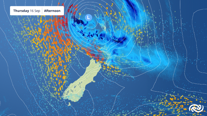
High pressure remains the main player over the South Island through to the weekend, but from Thursday, a low from the north brings strong winds and heavy rain to parts of the North Island, with Auckland in line for a wet and windy Thursday.
“As that low rolls down, it drives onshore easterly winds into Te Ika a Maui | North Island, bringing sub-tropical air with it. As that moist air hits the hills, we’re expecting heavy rain for Coromandel, Bay of Plenty and the east coast from East Cape to Wairarapa.”
James advises that the North Island’s forecast will be tweaked through the week as new information comes to light. “Lows from the north are complicated systems, and it usually takes a few days for computer weather models to get a good handle on what’s happening – keep an eye on the forecast as refinements will be made daily.”
 Gordon Campbell: On What’s Wrong With The Treaty Principles Bill
 NZ National Party: National Acknowledges The Passing Of Hon Nikki Kaye
 Mana Mokopuna: Children And Young People Share Vital Insights On Healing From Family Violence And Sexual Violence In New Report
 NZ Government: PM Marks One Year In Government
 Helen Clark Foundation: Helen Clark Foundation Calls For Political Action To Reduce The Prevalence Of Junk Food And Improve Health Outcomes
 Justice Committee: Further Decisions About Submissions Process For The Principles Of The Treaty Of Waitangi Bill
 Infrastructure New Zealand: Single Agency Needed To Coordinate Climate Adaptation And Recovery