Snow For Some – In Both Islands
While it may be the last month of meteorological winter, rainy and snowy weather shows no signs of slowing down for Aotearoa. MetService is forecasting a run of active weather into early next week, apart from a brief break on Saturday.
Waves of rain and showers continue for much of the country today (Thursday) and tomorrow (Friday) under a broad area of low pressure driven by an upper air weather system. This brings a risk of Heavy Rain for Mount Taranaki as well as the northwestern parts of the South Island, which are under a Severe Weather Watch.
Strong winds are also generated over the northern reaches of the country as a low pressure system crosses the North Island tomorrow. MetService meteorologist Mmathapelo Makgabutlane elaborates: “The combination of the low moving across, and gusty thunderstorms means parts of Auckland and Northland could get gusts around 90 km/h by the end of the day into early Saturday”.
Saturday sees a showery southwesterly regime for western parts of the country, while things ease up for rest of New Zealand. Those hoping for a rain-free Bledisloe Cup match in Auckland may yet get their wish, although match-goers will need to layer up against those cold southwesters.
The respite is short-lived, however, as the next low from the Tasman Sea arrives during Sunday, bringing rain and strong winds for the western and central parts of the country.
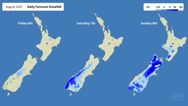
The real story, though, is the cold air that moves in behind the low, which significantly drops the snow level by the end of the weekend into early morning Monday. This brings snow down to low levels for the South Island, and even to the central plateau of the North Island. “We want to get the message out there good and early so that those with livestock can make the necessary preparations,” Makgabutlane commented.
Those with views of the Tararua Range will also be waking up to a fresh blanket of snow on Monday.
“The bulk of the snow will be before dawn when roads are typically quieter. However, some high level roads and mountain passes will be affected so, as always, people are encouraged to check road conditions before heading out,” Makgabutlane advised.


 Gordon Campbell: On What’s Wrong With The Treaty Principles Bill
 NZ National Party: National Acknowledges The Passing Of Hon Nikki Kaye
 Mana Mokopuna: Children And Young People Share Vital Insights On Healing From Family Violence And Sexual Violence In New Report
 NZ Government: PM Marks One Year In Government
 Helen Clark Foundation: Helen Clark Foundation Calls For Political Action To Reduce The Prevalence Of Junk Food And Improve Health Outcomes
 Justice Committee: Further Decisions About Submissions Process For The Principles Of The Treaty Of Waitangi Bill
 Infrastructure New Zealand: Single Agency Needed To Coordinate Climate Adaptation And Recovery


