 Scoop has an Ethical Paywall


Regional Community To Benefit From 3D Mapping Data
The first set of highly accurate 3D mapping data for the Bay of Plenty has been released as part of the Provincial Growth Fund LiDAR elevation data capture project, improving Bay of Plenty Regional Council’s ability to more accurately model natural hazards and climate change, design better infrastructure and improve environmental outcomes for the regional community.
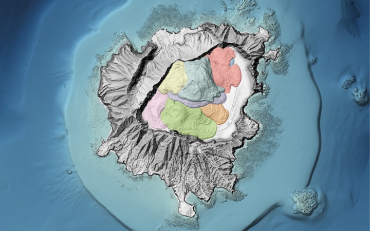
Mayor Island (Tūhua) Hillshade Blend. Shows the 6800 year old caldera collapse beneath the vegetation. Credit: LINZ
The data, which covers a significant portion of the western half of the region, is the second set to be released nationally as part of the project. Bay of Plenty Regional Council is one of 10 regional councils partnering with Toitū Te Whenua Land Information New Zealand to obtain a baseline elevation data set.
Co-funding from the Provincial Growth Fund is supporting the regional expansion of Toitū Te Whenua’s 3D mapping programme to provide a significant increase in national coverage.
Bay of Plenty Regional Council Digital Manager Evaleigh Rautjoki-Williams said LiDAR data can be processed to develop detailed digital versions of the ground terrain and surface features such as trees and buildings.
“The improved mapping data will be hugely beneficial in helping us in many aspects of our work, including in our flood modelling, as it provides accurate terrain and surface models of the land,” Ms Rautjoki-Williams said.
“We’ll be able to better understand where water will flow, what protection may be needed and where the areas at greatest risk from flooding will be.
“It will also benefit local industries such as agriculture, engineering and forestry that rely on an accurate understanding of the environment they operate in.”
The project also received support from the Bay of Plenty Local Authority Shared Service (BOPLASS) group. This has enabled the data to be shared between all councils in the region within existing Long Term Plan budgets.
BOPLASS CEO Stephen Boyle said LiDAR data is incredibly beneficial to all councils.
“It’s great to have been able to assist in making this first data release happen while providing cost savings to the councils through a collective approach,” Mr Boyle said.
The data is publicly available on the LINZ Data Service.
Data for the rest of the Bay of Plenty will be released progressively over the next three years, with the entire region covered by 2023.
 Gordon Campbell: On What’s Wrong With The Treaty Principles Bill
 Department Of Internal Affairs: Samoan Citizenship Bill Passes Into Law
 NZ National Party: National Acknowledges The Passing Of Hon Nikki Kaye
 Mana Mokopuna: Children And Young People Share Vital Insights On Healing From Family Violence And Sexual Violence In New Report
 NZ Government: PM Marks One Year In Government
 Helen Clark Foundation: Helen Clark Foundation Calls For Political Action To Reduce The Prevalence Of Junk Food And Improve Health Outcomes
 Justice Committee: Further Decisions About Submissions Process For The Principles Of The Treaty Of Waitangi Bill