MetService Issue Red Warning For Canterbury & Multiple Warnings Elsewhere
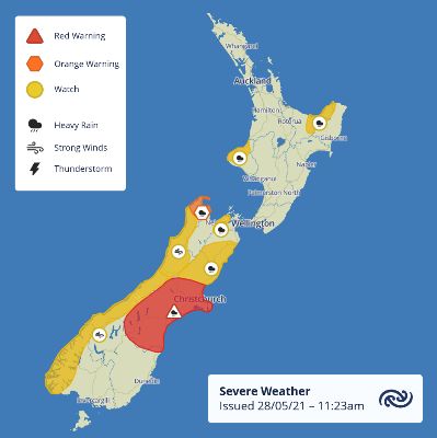
MetService are alerting people to a significant weather event affecting the country over the weekend. A complex low pressure system and associated fronts will move across the country from Saturday. It is bringing the risk of thunderstorms to the top of the country and periods of heavy rain to many regions, with significant and persistent falls in Canterbury along with large swells.
A Red Warning for Heavy Rain has been issued for the Canterbury region. Dangerous river conditions and flooding are expected. Slips and floodwaters are likely to disrupt travel, making some roads impassable and possibly isolating communities. People should also be prepared to follow the advice of official authorities and emergency services.
Red Warnings are reserved for only the most extreme weather events, such the severe weather resulting from ex-tropical cyclones, where significant impact and disruption is expected. It signifies that people need to act now as immediate action is required to protect people, animals and property from the impact of the weather. People should also be prepared to follow the advice of official authorities and emergency services.
“This is only the second Red Warning MetService that has been issued since the colour coded system was introduced mid-2019”, explains MetService Communications Meteorologist, Lisa Murray. “The first Red Warning was issued in February 2020 and caused significant impacts including roads being washed out trapping about 1000 people in Milford and rivers bursting their banks causing significant flooding in Southland.”
Murray advises that, “Apart from the Red Warning for Canterbury there is other significant weather around the country which people should be aware of including thunderstorms, wind, snow and swell.”
Elsewhere in the country there is a Heavy Rain Orange Warning for Nelson and a Thunderstorm Watch also covers parts of Nelson and areas in the top half of the North Island. There is a Strong Wind Watch for Westland and Fiordland for southeasterly winds approaching gales in exposed places. There are also concerns for some coastal areas due to king tides and large swell over the weekend, these areas include Auckland, Bay of Plenty and Canterbury.
An event of this nature is evolving so it
is particularly important to stay up to date with the latest
information from MetService.
Weather Warnings: http://bit.ly/AllWarnings
Thunderstorm
Outlook: http://bit.ly/TSOutlook
Marine
forecasts: https://www.metservice.com/marine


 Gordon Campbell: On The Americanising Of NZ’s Public Health System
 Walk Without Fear Trust: New Sentencing Reforms Aimed At Restoring Public Safety Welcomed
 Rio Tinto & NZAS: Archaeological Project Underway From Historic Excavations At Tiwai Point
 New Zealand Deerstalkers Association: NZDA Urges Hunters To Prioritise Safety This Roar Season
 PSA: 1000 Days Since Landmark Pay Equity Deal Expired - Workers Losing $145 A Week
 Grace Tinetali-Fiavaai, RNZ: Widow Of Fa'anānā Efeso Collins Seeks Inquiry Into His Death - 'Unanswered Questions'
 Te Pāti Māori: Te Pāti Māori Call For Mandatory Police Body Cameras


