High Pressure Holds
A ridge of high pressure holds strong for the rest of the working week, bringing settled and dry conditions across Aotearoa says MetService.
The majority of the country will see partly cloudy or foggy mornings, followed by fine afternoons, however a front pushes onto Fiordland and Westland tonight and into Tuesday morning.
MetService meteorologist Ashlee Parkes elaborates; “A Heavy Rain Watch has been issued for Fiordland and the ranges of Westland south of Harihari. Periods of heavy rain are expected for these areas from 6:00am Tuesday morning, with thunderstorms also possible for Fiordland. Scattered falls will spill further east into the Southern Lakes, across to Dunedin and south through to Southland in the afternoon and evening.”
This feature will stall over Westland on Wednesday, before easing and clearing during the overnight period. Settled conditions then return and persist for the rest of the working week.
Parkes continues “There will be a few showers for Stewart Island on Thursday while Hawke’s Bay and Gisborne will also see a few on Friday.”
After the past run of cold and frosty mornings, temperatures will return to normal for most. Parkes explains “The front will bring a northwest flow across the South Island mid-week. Eastern areas will therefore see warmer than average temperatures. Christchurch is forecast to reach a maximum of 22C on Tuesday, and Blenheim looks to hit 23C on Wednesday”.
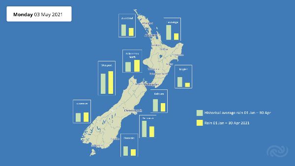
Unsettled conditions are on the horizon for the weekend, but until then, many areas are in for another dry spell with a lot of centres already below their typical rain accumulation for the year so far.


 Gordon Campbell: On What’s Wrong With The Treaty Principles Bill
 NZ National Party: National Acknowledges The Passing Of Hon Nikki Kaye
 Mana Mokopuna: Children And Young People Share Vital Insights On Healing From Family Violence And Sexual Violence In New Report
 NZ Government: PM Marks One Year In Government
 Helen Clark Foundation: Helen Clark Foundation Calls For Political Action To Reduce The Prevalence Of Junk Food And Improve Health Outcomes
 Justice Committee: Further Decisions About Submissions Process For The Principles Of The Treaty Of Waitangi Bill
 Infrastructure New Zealand: Single Agency Needed To Coordinate Climate Adaptation And Recovery


