 Scoop has an Ethical Paywall


Four Sleeps, Two Lows, A Good Dose Of Rain But No Tropical Cyclones To Go Until Christmas
MetService are forecasting a cloudy run in to Christmas, with some significant rain and strong winds especially around Christmas Eve. For Christmas Day however a southerly change ushers in clearer skies and cooler temperatures, although areas in the south and east will continue to see showers.
“The main player in our weather is a slab of warm air reaching across New Zealand from the Tasman Sea,” explains MetService meteorologist Tom Adams.
“The remains of ex-tropical cyclone Yasa are still circulating in the Pacific, but the system has been re-classified as an extra-tropical low, is not coming near to New Zealand and will not affect our weather.”
Two low pressure systems form on the southern edge of the warm air in the Tasman Sea however, crossing Aotearoa on Tuesday and on Christmas Eve. The first and smaller of these lows will bring heavy rain to the South Island West Coast, but its effects are muted over the North Island although cloud and the odd shower are still to be expected for most places tomorrow. Cloud and rain stick around on Wednesday, with strengthening northwesterly winds.
The second low will cross on Christmas Eve and has the potential to bring challenging conditions for people travelling between the regions ahead of the holidays. Northerly gales for central New Zealand and heavy rain for the western and upper South Island are all highlighted in the Severe Weather Outlook, and it is likely that Severe Weather Watches and Warnings will be issued closer to the event. Once again though, the upper North Island will see a cloudy and occasionally wet day, but the worst effects will be further south.
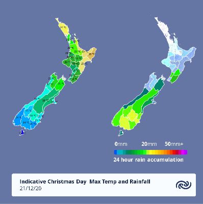
The low will have passed by Christmas Day leaving cooler southerly winds behind it. Areas exposed to the southerly such as Dunedin, Christchurch, Wellington and the Kaikoura Coast can expect a few showers, but more western and northern areas like Auckland, Taranaki, Nelson and the Waikato are looking at a drier, sunnier day to start the holidays. The pick of locations that get that combination of warmth and sun for Christmas would be Gisborne, Bay of Plenty of Northland. Another weak front does move up the country on Boxing Day, but overall we see an improving trend through the weekend although unsettled conditions return the following week.
 Gordon Campbell: On The Hikoi Aftermath
 Infrastructure New Zealand: Single Agency Needed To Coordinate Climate Adaptation And Recovery
 Free Speech Union: Fair Digital News Bargaining Bill Likely To Restrict Access To Information, Polling Shows Most Oppose
 Auckland Transport: Driver Safety Screens Now Rolling Out Across Auckland’s Bus Fleet
 People Against Prisons Aotearoa: 'Expect Resistance' - Community Group Pushes Back Against More Cops With Guns
 Greenpeace: New Zealand Drops In Global Ranking On Climate Action
 PSA: Spending Cuts Need To Stop - PSA Urges Govt To Listen To Economists