Settled Weather On The Horizon
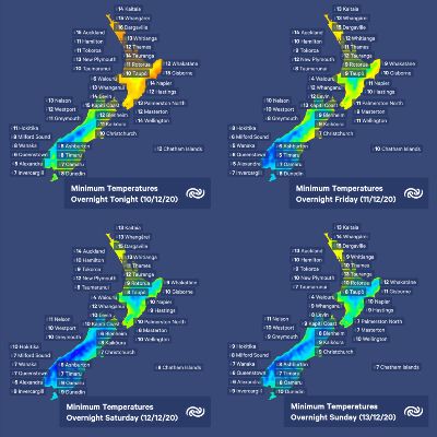
After a last bout of rain, MetService is forecasting a fine weekend for most. The passage of a series of fronts is set to clear out the muggy weather and lower temperatures to near seasonal averages.
MetService meteorologist Alwyn Bakker explains, “A stream of warm, moist tropical air over the country is being forced away by a series of fronts moving in from the southwest. The fronts bring rain today (Thursday) and tomorrow, with most of Aotearoa/New Zealand becoming fine on Saturday, although a few showers linger in western regions until Sunday.”
Strong Wind Warnings for northwesterly gales have been issued for tomorrow. The Canterbury High Country is expected to see gusts of up to 130 km/h early Friday morning, and gusts of up to 120 km/h are forecast during the morning and afternoon for Wellington and parts of the Wairarapa.
The Otago radar went live today, the tenth in MetService’s national network, and the upcoming periods of rain should provide a good workout for the new radar station.
Cooler air behind the fronts puts an end to the muggy nights experienced over the last few days, with temperatures returning to near seasonal averages for most, with the Deep South dipping below average. Parts of Southland are expected to pick up a light dusting of snow above 500m overnight tonight. Although snow flurries are unusual for this time of year, they are not unheard of.
There is good news for the cricket fans among us. The weather in Wellington is set to be fine, if initially windy, for the Blackcaps – West Indies match, starting tomorrow in the Basin Reserve.
Farther afield, tropical cyclone season kicked off at the beginning of November and this weekend looks likely to see the first TC in the South Pacific form between Vanuatu and Fiji. As the TC will form in Fiji's area of responsibility, RSMC Nadi will officially name and initiate warnings once the cyclone develops. Initially the TC is expected to track to the southwest, but it's still too early to call where and when it will exit the tropics. Our specialist TC meteorologists are monitoring developments closely and will keep you updated at: https://www.metservice.com/warnings/tropical-cyclone-activity


 Gordon Campbell: On Winston Peters’ Battle Against The Phantom Legions Of The Woke
 Greenpeace: Luxon’s Investment Claims Undermined By Breaches Of Free Trade Agreements
 Living Wage Aotearoa: Government Cleaners, Security Guards, And Caterers Counting On NZ First
  Environmental Defence Society: Infrastructure Summit Should Prioritise Environmental Outcomes
 Green Party: Just Six Government MPs Needed To Pass Unlawful Occupation Of Palestine Sanctions Bill
 Ngāti Manuhiri Settlement Trust: Iwi Welcomes Progress On Northland Expressway
 Kick Back: Urgent Review Of MSD Needed To Prevent More Rangatahi Sleeping Rough


