 Scoop has an Ethical Paywall


Summer Dragging Its Heels
Hints of summer are showing, however MetService is forecasting a mix of wet, warm and windy weather to dominate this week.
MetService meteorologist Tahlia Crabtree explains, “High pressure northeast of the country is steering warm, tropical air in a stream across the North Island, which will drive significant rainfall to lower western and central regions from today through to Wednesday.”
Persistent heavy rain in the Kāpiti-Horowhenua (Heavy Rain Warning) and Taranaki (Heavy Rain Watch) regions will see rainfall exceed 100mm, while catchments in the Tararua Ranges can expect accumulations up to 350mm. “Rivers will swell, roads may see surface flooding – make sure to take care, and stay up to day with NZTA and local council updates,” advises Crabtree.
Where it isn’t raining in the North Island, it’s blowing - Strong Wind Watches are are in place for Wellington, Marlborough, Wairarapa for northwest gales until Tuesday evening.
Other parts of the country are exempt from the wettest weather, and instead are competing for first to 30°C. Christchurch has the highest chance for Monday (high 29°C), then Whangārei and Napier battle it out for Tuesday and Wednesday. However, Hawke’s Bay may take the win for warmest night, with an overnight minimum of 21°C an uncomfortable 8°C above average for December.
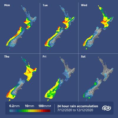
Thursday sees a spell of settled weather and a return to average temperatures across the country, before the next period of rain moves up the South Island to end the week.
 Gordon Campbell: On The History Of Doo Wop Music
 Wellington City Council: 'I Am Focused On Continuing The Momentum' – Mayor Tory Whanau
 Love Food Hate Waste: From Overbuying To Overcooking - Food Waste Challenges Impacting Smaller Households
 NZ Government: Strong Biosecurity More Important Than Ever
 Environmental Defence Society: Regulatory Standards Bill Should Be Stopped In Its Tracks
 NZ Police: A Minute's Silence And Livestream Of Funeral Service For Senior Sergeant Lyn Fleming
 Socialist Equality Group: Foreign Interference Bill Prepares New Attacks On Democratic Rights