Summer Starts With A Spring-like Weekend
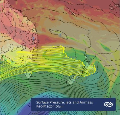
Although the run in to Christmas looks primed for settled weather, MetService is forecasting boisterous spring-like conditions for the upcoming weekend.
MetService meteorologist Tom Adams explains, “Classic spring weather is high pressure to the north and a strong subtropical jet. This drives westerlies with embedded fronts over much of the country and that’s what we see this weekend.”
Auckland lies under that high pressure, so will be warm and mostly dry. However, the roaring jet aloft means that high cloud will be a common occurrence, although there should be plenty of sun in the gaps. Then from Monday onwards low cloud and humidity get added to the mix. The same can be said for much of the North Island, although western areas like Hamilton – who will be hosting the first Test Cricket match for the Black Caps since Covid-19 struck - can expect a few showers later on Saturday. The Downtown Shakedown taking place in Wellington on Saturday will see strong northwesterly winds, with some rain or showers in the afternoon, but will have all of Sunday to dry out and even a brief break in the wind.
The South Island also meets its spring stereotype square-on, with periods of rain in the west and a few showers drifting over to the east with a risk of thunderstorms Saturday afternoon. The gale westerlies currently racing over the far south are on an easing trend into the weekend.
The extended spring will continue into the start of next week, with another period of rain likely mid-week, but from Thursday onwards settled conditions set the trend for a more stable and summery run in to the holidays.


 Gordon Campbell: On Winston Peters’ Battle Against The Phantom Legions Of The Woke
 ActionStation: Economists, Campaign Groups Hit Out At PPP’s Labelling Them ‘Ideological, Reckless’
 Greenpeace: Luxon’s Investment Claims Undermined By Breaches Of Free Trade Agreements
 Living Wage Aotearoa: Government Cleaners, Security Guards, And Caterers Counting On NZ First
  Environmental Defence Society: Infrastructure Summit Should Prioritise Environmental Outcomes
 Green Party: Just Six Government MPs Needed To Pass Unlawful Occupation Of Palestine Sanctions Bill
 Ngāti Manuhiri Settlement Trust: Iwi Welcomes Progress On Northland Expressway


