 Scoop has an Ethical Paywall


An Uncharacteristic Start For The First Day Of Summer
MetService is forecasting cold and wet weather for most today - the last day of spring, with the South Island the place to be for first day of summer.
MetService meteorologist Andy Best says, “Strong, cold southerly winds and rain affect much of central New Zealand today and on Tuesday as an irritable low pressure system tracks across the country.”
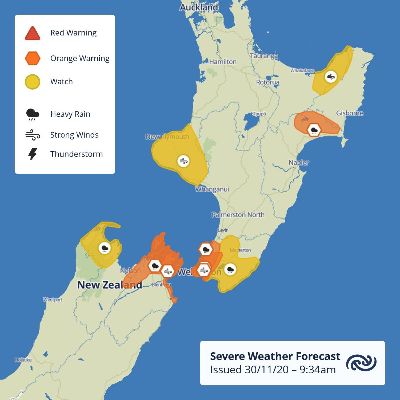
“This low brings more heavy rain over the Wellington and Marlborough districts and Severe Weather Warnings (orange) have been issued for heavy rain and strong southerly winds. In addition, the low brings a period of heavy northerly rain to northwest Nelson today and to parts of Wairarapa tonight and into Tuesday,” comments Best.
There is also a Strong Wind Watch in place for Taranaki valid from early Tuesday morning to around midday, associated with southerly winds and another for eastern Bay of Plenty from Tuesday afternoon until about midnight. The developing low has also resulted in a Heavy Rain Warning being issued for the Wairoa District valid from Tuesday morning until late Tuesday evening. Also, on Tuesday, strong south to southwesterlies (possibly rising to gale) are forecast to spread over Auckland in the morning before easing in the evening.
The good news for the first day of meteorological summer is a building ridge of high pressure across the whole of the South Island brings settled, fine weather on Tuesday. But a cool start for some, with Alexandra residents waking to just 4 degrees around dawn. It will be also be a cool Tuesday across parts of Marlborough and Canterbury, with maximum temperatures around the low teens.
On Wednesday, it’s the turn of the North Island to take charge of the ridge. Most places can look forward to a fine day, with light winds and temperatures returning to about average for his time of year. Both Hamilton and Masterton should see a maximum of 23C with 22C the high in Auckland and for much of Northland. Over the South Island on Wednesday, a front approaching from the Tasman Sea will generate strong northwesterly winds, with possible severe gales from Marlborough to Stewart Island. These nor'westers are expected to push temperatures up to 23C for Kaikoura, Oamaru and Dunedin. The front also brings rain to Westland and Fiordland.
On Thursday, the front marches up the country, reaching the central North Island around midday, and is preceded by northwesterlies. A band of showers ease with the passage of the front, leaving fine conditions and southwesterly winds. Much of the South Island becomes fine, with gusty west or southwest winds dying away in the evening.
 Gordon Campbell: On The Mock Horror Over Political Profanity
 Community Access Media Alliance: CAMA Urges Government To Recognise Community Access Media As Lifeline Utility In New Emergency Management Laws
 NZ Customs Service: Man Sentenced To 4 Years & 9 Months’ Imprisonment Following Customs Investigation Into Child Sexual Abuse Material
 Human Rights Commission: Human Rights Commissioner Says The Cost Of Limiting Gender Rights Under Legislation Will Be People's Lives
 New Zealand Government: Social Security Amendment Bill Passes Into Law
 Independent Police Conduct Authority: IPCA Investigations Relating To The Conduct Of Former Deputy Commissioner McSkimming
 PSA: New Public Research Organisation Boards Dominated By Men