 Scoop has an Ethical Paywall


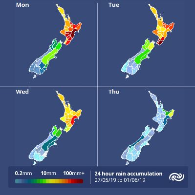
Lingering Low Brings Heavy Rain And Thunderstorms
MetService is forecasting the broad low pressure system which is currently over the North Island to linger until the middle of the week, when it finally gets pushed eastwards by a ridge of high pressure.
Meteorologist Rob Kerr says, “From now through to later Wednesday, parts of the North Island will see heavy rain or showers, with thunderstorms and hail possible, while strong or gale south to southeast winds affect the lower North Island and Cook Strait."
“Severe Weather Warnings and Watches are in place across eastern parts of the North Island for Monday and Tuesday, with the main area of concern being the ranges of Hawke’s Bay and southern Gisborne, where 100-130mm of rain could accumulate in 13 hours today. This is a large amount of rain in a short period and isolated downpours could see totals exceed that range which may bring about slips and rapidly rising streams.,” Kerr adds.
“Another band of rain or showers hooking around the low triggered Tuesday’s rain Watches in the northeast, then continues southwards and could bring a further burst of heavy rain to Hawke’s Bay on Wednesday before the low pulls away,” Kerr says.
“Conditions are far more settled over the South Island during this period, with cloud and just a few showers for eastern parts of the Mainland, and sunny days for West Coasters, spoiled only by gusty southeast winds squeezing down some valleys,” says Kerr.
The high pressure building over the Tasman Sea midweek pushes the low away to the east later on Wednesday, then rolls onto the North Island during Thursday and Friday, bringing much more settled conditions. However, that will mean a return to familiar strong or gale northwest winds for South Islanders and Wellingtonians, boosting Canterbury and Otago temperatures into the mid to high twenties.
 Gordon Campbell: On What’s Wrong With The Treaty Principles Bill
 Department Of Internal Affairs: Samoan Citizenship Bill Passes Into Law
 NZ National Party: National Acknowledges The Passing Of Hon Nikki Kaye
 Mana Mokopuna: Children And Young People Share Vital Insights On Healing From Family Violence And Sexual Violence In New Report
 NZ Government: PM Marks One Year In Government
 Helen Clark Foundation: Helen Clark Foundation Calls For Political Action To Reduce The Prevalence Of Junk Food And Improve Health Outcomes
 Justice Committee: Further Decisions About Submissions Process For The Principles Of The Treaty Of Waitangi Bill