Wintry Conditions To Break Settled Run
New Zealand
says goodbye to the high pressure that has dominated for the
last couple of weeks, as a low from the Tasman Sea and
associated fronts move up the country from today (Thursday).
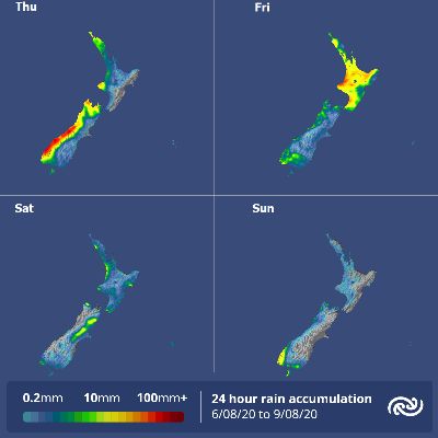
MetService is forecasting a change in conditions as the
pattern shifts from dry and settled to wet and
cool. The first of several fronts trundles up western
South Island today, with rainfall becoming heavy for parts
of the southwest and far north, where there is a Heavy Rain
Watch in force. MetService meteorologist Mmathapelo
Makgabutlane elaborates: “Southern Westland and Fiordland
may get heavier falls, especially with thunderstorms later
today. The Richmond and Tasman ranges could also see some
significant rainfall amounts thanks to strong northerly
winds with this front.” The upper North Island gets
its first taste of the front late tonight as the day’s
showers turn to rain, with the odd thunderstorm, and that
template gets carried over into Friday. But perhaps the
biggest change will be felt by those in the lower North
Island when the front moves across the island on Friday,
bringing a rainy end to what has been two weeks of
unseasonably calm weather. Another feature of the low
is the strong southerly push of colder air late tomorrow,
bringing snowfalls to the far south and up the eastern South
Island on Saturday morning – a reminder that the country
is still well in winter’s grip. This is echoed by
Saturday’s daytime temperatures, as Makgabutlane explains:
“Parts of the South Island can expect a return to
single-digit maximum temperatures, and the capital only
reaches 10°C”. The series of fronts that follows
ensures that most of Aotearoa sees some wet weather by the
end of Saturday, before the fronts clear out and bring a dry
day on Sunday for many. The North Island won’t need to
wait too long for the next bout of rain, however, with
another low from the Tasman approaching early next
week.


 Gordon Campbell: On What’s Wrong With The Treaty Principles Bill
 Department Of Internal Affairs: Samoan Citizenship Bill Passes Into Law
 NZ National Party: National Acknowledges The Passing Of Hon Nikki Kaye
 Mana Mokopuna: Children And Young People Share Vital Insights On Healing From Family Violence And Sexual Violence In New Report
 NZ Government: PM Marks One Year In Government
 Helen Clark Foundation: Helen Clark Foundation Calls For Political Action To Reduce The Prevalence Of Junk Food And Improve Health Outcomes
 Justice Committee: Further Decisions About Submissions Process For The Principles Of The Treaty Of Waitangi Bill


