 Scoop has an Ethical Paywall


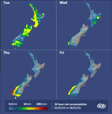
The Rain Has Come, Will It Stay?
Precipitation has graced Aotearoa soils over the last 24 hours and continues today (Monday) for some places, no doubt a relief for many kiwis! Will the rain last? It will today for most, however for the rest of the week, MetService has a more settled prognosis; fine and dry for most. Following a cold southerly, temperatures indicate that we are nearly in winter.
Pouring rain across the North Island had gleeful reactions on social media. Rainfall in excess of 50mm fell overnight and into this morning in many places under the upper North Island under a frontal system that crossed the country, also bringing strong wind gusts nearing 120km/h in exposed locations – the MetService weather station in Kelburn, Wellington recording a 109km/h gust yesterday morning.
Squally showers and thunderstorms are expected for the North Island today, while a southerly change migrates up towards the North Island, bringing more potential for intense showers, thunder and strong winds.
MetService meteorologist Tui McInnes remarks, “It’s not quite winter yet, so this cold blast does serve as a reminder that winter isn’t far away.” The colder temperatures will bring snow to the lower mountains, possibly down to 500 metres in the far south with a number of Road Snowfall Warnings in place. However, the weather isn’t entirely cold and wet.
At this point in time, the week’s weather is set to end on a high, literally. McInnes explains, “High pressure and settled conditions let the temperatures rebound, the winds die out and give us some sun to enjoy in our bubbles.”
Understanding our Severe Weather Watches and Warnings
Outlooks are about looking ahead:
- To provide advanced information on possible future Watches and/or Warnings
- Issued routinely once or twice a day
- Recommendation: Plan
Watches
are about being alert:
- When severe weather is possible, but not sufficiently imminent or certain for a warning to be issued
- Typically issued 1 - 3 days in advance of potential severe weather.
- During a Watch: Stay alert
Orange Warnings
are about taking action:
- When severe weather is imminent or is occurring
- Typically issued 1 - 3 days in advance of potential severe weather
- In the event of an Orange Warning: Take action
Red Warnings
are about taking immediate action:
- When extremely severe weather is imminent or is occurring
- Issued when an event is expected to be among the worst that we get – it will have significant impact and it is possible that a lot of people will be affected
- In the event of a Red Warning: Act now!
 Gordon Campbell: On What’s Wrong With The Treaty Principles Bill
 Department Of Internal Affairs: Samoan Citizenship Bill Passes Into Law
 NZ National Party: National Acknowledges The Passing Of Hon Nikki Kaye
 Mana Mokopuna: Children And Young People Share Vital Insights On Healing From Family Violence And Sexual Violence In New Report
 NZ Government: PM Marks One Year In Government
 Helen Clark Foundation: Helen Clark Foundation Calls For Political Action To Reduce The Prevalence Of Junk Food And Improve Health Outcomes
 Justice Committee: Further Decisions About Submissions Process For The Principles Of The Treaty Of Waitangi Bill