 Scoop has an Ethical Paywall


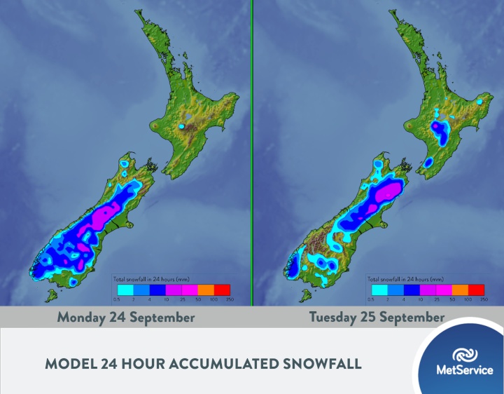
More spring snow this week
It’s the Spring Equinox today, which is when the overhead sun shifts from the northern hemisphere to the southern hemisphere. The hours of daylight and nighttime are of approximately equal duration all over the planet, and in New Zealand the hours of daylight will continue to increase through to the summer solstice on 22 December.
Despite transitioning into our meteorological spring more than three weeks ago, another cold snap is on the way this week, with snow forecast to low-levels over the South Island. MetService Meteorologist Peter Little said, “A low is expected to develop on a cold front east of the South Island tonight, then remain slow-moving through Monday. This low will direct a cold southeasterly flow over the South Island, bringing significant snowfall to high country areas. Road snowfall forecasts are in force for several passes, and a Severe Weather Watch has also been issued for the possibility of heavy snow in parts of Otago and Canterbury on Monday and Tuesday. In addition, heavy rain is possible about eastern Otago.”
As the low moves eastwards on Tuesday, the cold air surges over the remainder of the country, followed by a period of strong to gale force southwest winds. “As this wintry blast spreads northwards on Tuesday, snow will fall across higher parts of the North Island, with the Desert Road likely to be affected. There may even be a dusting of snow near the summit of the Remutaka Hill Road north of Wellington”, added Little.
 Gordon Campbell: On What’s Wrong With The Treaty Principles Bill
 Ministry For Culture And Heritage: Reverberations Of Erebus Disaster Still Felt 45 Years Later
 Watercare Services: No Cause For Concern After Slightly Elevated Levels Of Arsenic Detected In Treated Waikato River Water
 Te Pāti Māori: Government’s First Year A ‘Catastrophe For Māori’
 Department Of Internal Affairs: Samoan Citizenship Bill Passes Into Law
 NZ National Party: National Acknowledges The Passing Of Hon Nikki Kaye
 Mana Mokopuna: Children And Young People Share Vital Insights On Healing From Family Violence And Sexual Violence In New Report