 Scoop has an Ethical Paywall


Two contrasting weather systems affect New Zealand this week
Two contrasting weather systems affect New Zealand this week
The cold southerlies which affected southern and eastern parts of the North Island last weekend eased on Monday as the low pressure system moved well east of Aotearoa. MetService meteorologist Andy Best commented “The upper half of the North Island had to contend with unsettled weather during Monday and Tuesday as a complex trough moved over the area.” He went on to say, “Wednesday saw the arrival of a welcome ridge of high pressure which spread from the Tasman Sea across the whole of the country, and brought fine conditions with lots of Spring sunshine.” The only downside to the ridge was that clear nighttime skies brought chilly overnight temperatures, with frosts, low cloud and fogs for many inland areas.
MetService meteorologists are currently focusing on a couple of major weather systems which are expected to bring severe weather conditions across the country during the next few days. The first being a low with associated fronts which approaches the South Island today, and moves across the island during Monday and early Tuesday. Ahead of this feature are strong northwesterly winds affecting the lower half of the South Island as well as heavy rain forecast for parts of Fiordland and Westland. The system tracks southeast on Monday bringing very cold air over lower parts of the South Island. A heavy snow watch and road snow warnings are in force for regions and roads in the southern half of the South Island.
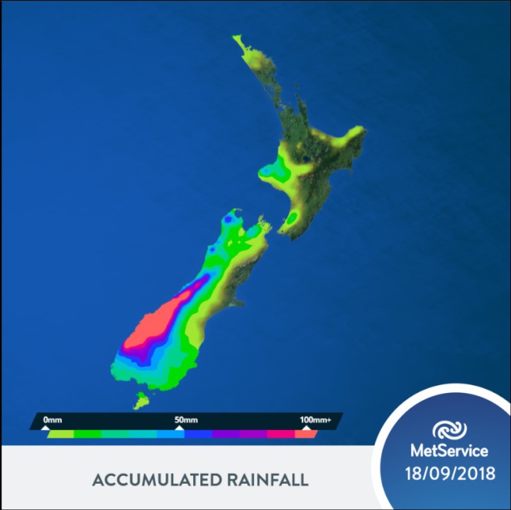
The second weather feature is a subtropical low expected to move southwards over the waters east of the North Island during Tuesday and Wednesday. There is currently computer model uncertainty about the track of this low, therefore we have a low risk that rainfall accumulations could approach warning amounts about Northland, Auckland, Coromandel Peninsula, Bay of Plenty and northern parts of Gisborne from Tuesday to Wednesday. The image below shows the expected accumulated rainfall from early today (Sunday) up until midnight Tuesday.
 Gordon Campbell: On What’s Wrong With The Treaty Principles Bill
 Ministry For Culture And Heritage: Reverberations Of Erebus Disaster Still Felt 45 Years Later
 Watercare Services: No Cause For Concern After Slightly Elevated Levels Of Arsenic Detected In Treated Waikato River Water
 Te Pāti Māori: Government’s First Year A ‘Catastrophe For Māori’
 Department Of Internal Affairs: Samoan Citizenship Bill Passes Into Law
 NZ National Party: National Acknowledges The Passing Of Hon Nikki Kaye
 Mana Mokopuna: Children And Young People Share Vital Insights On Healing From Family Violence And Sexual Violence In New Report