 Scoop has an Ethical Paywall


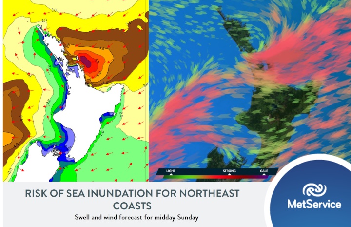
Severe Weather to Hit Just in Time for King Tides
A low pressure system currently lying to the northeast of New Zealand is set to end the week on a wet and windy note.
“While there is still some uncertainty on the severity of the heavy rain and strong winds forecast ahead of this low, it is certain that northern and eastern regions of the North Island will see some wild weather this Sunday” April Clark MetService Meteorologist said.
Severe Weather Watches and Warnings are already in force over areas north (and including) the central plateau along with parts of the Nelson and Marlborough regions. These Warnings and Watches are largely for the potential of strong easterly winds and heavy rain, though a greater confidence in the likelihood of rainfall totals reaching 70mm or above about ranges between Gisborne and Bay of Plenty mean they are under a Heavy Rain Warning already.
“The reason this event is different from your usual winter storm, is due to its coincidence with king tides” Clark reported, “Not only is the usual surface flooding, slips and flying debris a risk on Sunday, but king tides combined with low pressure and heavy northeast swell mean that sea inundation is a possibility for vulnerable eastern coasts from Northland through to the Bay of Plenty” she continued.
Those in at risk areas are urged to keep an eye on the forecast as Heavy Rain and Strong Wind Watches may be added to or upgraded to Warning this evening as the exact path of the low center becomes more certain. Those concerned about disruptions or damage due to sea inundation should also keep up to date with tide times and our marine forecasts along with any advice from their local councils as they head into Sunday.
 Gordon Campbell: On What’s Wrong With The Treaty Principles Bill
 Ministry For Culture And Heritage: Reverberations Of Erebus Disaster Still Felt 45 Years Later
 Watercare Services: No Cause For Concern After Slightly Elevated Levels Of Arsenic Detected In Treated Waikato River Water
 Te Pāti Māori: Government’s First Year A ‘Catastrophe For Māori’
 Department Of Internal Affairs: Samoan Citizenship Bill Passes Into Law
 NZ National Party: National Acknowledges The Passing Of Hon Nikki Kaye
 Mana Mokopuna: Children And Young People Share Vital Insights On Healing From Family Violence And Sexual Violence In New Report