 Scoop has an Ethical Paywall


Severe weather Sunday a taste of things to come
A series of low pressure centres filing past Stewart Island will bring an unsettled westerly weather pattern to the country this week, with the first low pressure system moving past on Sundayafternoon. As well as strong to gale westerlies, each low centre will direct a brief southerly change up New Zealand, and bring rain, snow and thunderstorms to parts of the country.
The entire South Island, as well as the lower North Island, is currently under a Severe Weather Warning or Watch for west to northwest gales today. Current forecasts suggest that the Canterbury High Country and foothills, as well as Marlborough, Wellington and the Wairarapa, will be the windiest places, and each of these places may see wind gusts of 140km/hr. Western parts of the South Island will see a double dose of severe weather, with Warnings out for heavy rain and high risks for thunderstorms in Fiordland, Westland and about the Southern Alps, as the frontal system progresses northwards this afternoon.
Behind todays front, the wind direction shifts to the southwest, and deep, cold air pushes across the South Island, bringing snow to low levels. Current forecasts are for the snow to lower to 600m in the far south Sunday evening, then further lower to 300m for a time early on Monday for Fiordland, Southland and parts of Otago.
“Strong wind will certainly be the most noticeable weather for many people this week,” said MetService Meteorologist Angus Hines, “but with the upcoming cold southerly changes, and a procession of fronts providing moisture, is also looks likely that snow levels will lower even further as the week goes on. There are already many Road Snow Warnings in place for higher South Island passes, and it looks inevitable that more roads will be affected and more warnings issued. It’s safe to say that winter is coming.”
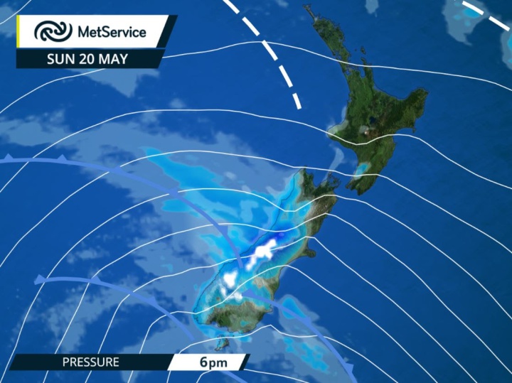
Snapshot of frontal positions
at 6pm Sunday. Heavy rain in the west, strong wind for many
places.
 Gordon Campbell: On What’s Wrong With The Treaty Principles Bill
 Ministry For Culture And Heritage: Reverberations Of Erebus Disaster Still Felt 45 Years Later
 Watercare Services: No Cause For Concern After Slightly Elevated Levels Of Arsenic Detected In Treated Waikato River Water
 Te Pāti Māori: Government’s First Year A ‘Catastrophe For Māori’
 Department Of Internal Affairs: Samoan Citizenship Bill Passes Into Law
 NZ National Party: National Acknowledges The Passing Of Hon Nikki Kaye
 Mana Mokopuna: Children And Young People Share Vital Insights On Healing From Family Violence And Sexual Violence In New Report