Westerlies make it Wet in the West
Westerlies make it Wet in the West.
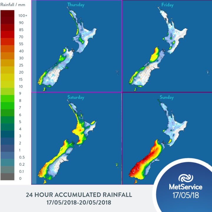
MetService is forecasting rain and showers for those in the west of the country in the lead up to the weekend, while most places east of the ranges remain dry and sunny.
The northern and eastern areas of the North Island should expect a nice day on Friday, with some good sunshine filtered by high cloud. The good weather is also expected through most of the eastern South Island.
“The wettest part of the country for leading up to the weekend will be Buller, which is on a Severe Weather Watch for heavy rain as a front lingers over the region today and tomorrow,” explains MetService meteorologist Kyle Lee.
On Saturday, a front is expected to bring more wet weather to the western North Island, with the Tararua Range also on alert for Severe Weather from tomorrow afternoon.
“This won’t be welcome news for places like Taranaki, who’ve had a fair share of wet weather this week already,” said Lee.
The South Island won’t be spared for wet weather and will also see it accompanied by progressively cooler temperatures. On Sunday, rainfall accumulations particularly wet for most the Island, with snow expected to lower at this stage down to 500 or 600 metres in Fiordland and Central Otago early Sunday.
The colder weather will be the trend from next week as we see the westerly wind regime start to turn more southerly, exposing us to the colder temperatures from the Southern Ocean. It seems that indeed, winter is on its way both officially (from 1st June) and temperature-wise, so time get the winter wardrobe out – if you haven’t already.


 Gordon Campbell: On What’s Wrong With The Treaty Principles Bill
 Ministry For Culture And Heritage: Reverberations Of Erebus Disaster Still Felt 45 Years Later
 Watercare Services: No Cause For Concern After Slightly Elevated Levels Of Arsenic Detected In Treated Waikato River Water
 Te Pāti Māori: Government’s First Year A ‘Catastrophe For Māori’
 Department Of Internal Affairs: Samoan Citizenship Bill Passes Into Law
 NZ National Party: National Acknowledges The Passing Of Hon Nikki Kaye
 Mana Mokopuna: Children And Young People Share Vital Insights On Healing From Family Violence And Sexual Violence In New Report


