 Scoop has an Ethical Paywall


MetService: Early Winter Storm
Early Winter Storm
Severe Weather Watches and Warnings have been issued for the start of the working week. A low pressure system approaching from the Tasman Sea, and a strong cold front approaching from the Southern Ocean are expected to come together to bring heavy rain, gale force winds and thunderstorms to many parts of the country, and heavy snowfall is also in the forecast.
A Severe Weather Watch has been issued for heavy rain for the ranges of Buller and northwest Nelson, as well as lower lying parts of Canterbury and Kaikoura Coast, starting late on Mondayand continuing into Tuesday. In addition, the first Heavy Snowfall Warning and Watches of 2018 have been issued for eastern parts of the South Island above 300 – 400 metres.
MetService Meteorologist Claire Flynn explained that the coastal towns and cities in the east of the South Island were likely to see heavy rain rather than snow, being too close to sea level, but she stressed that those who were planning on travelling would need to ensure they were on top of the latest weather updates.
“There are heavy snowfall warnings in place for the Canterbury High Country and Kaikoura Ranges above 400 metres, and snowfall Watches for Otago, Southland and Fiordland above 300 metres. In addition, road snowfall warnings have been issued for many of the alpine passes, with Lewis, Arthurs and Porters Pass expected to be worst affected, with up to half a metre of snow possible on Tuesday,” she said. “Those closer to the coast will likely get heavy rain. While we may not see snow in Christchurch City, for example, higher roads of Banks Peninsula are likely to be affected by snowfall.”
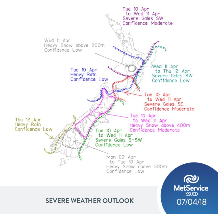
Snow is also likely for the central North Island from Tuesday night and into Wednesday, and there is potential for Severe Weather Watches and Warnings could be issued for these areas as well. Meanwhile, those further north in Auckland will not be exempt from the severe weather, with gale westerlies and squally thunderstorms possible on Tuesday.
“People need to read the forecast for their area, including the Severe Weather Warnings and Watches, and take steps to prepare if they are in the affected areas,” advised Flynn. “Tying down trampolines, avoiding unnecessary travel, and clearing gutters are just a few steps people can take. There is the potential that the severe weather could disrupt power as well. If people are unsure where to start, there is good information on preparing for severe weather at the Get Thru website. You can also check current road conditions and closures on the NZTA website.” The Get Thru website can be found at http://info.metraweather.com/e/60812/2018-04-07/fsfrch/687836698 , and information about our state highways can be found athttp://info.metraweather.com/e/60812/traffic/fsfrck/687836698
The severe weather making its way to New Zealand will be here in time for the anniversary of another significant weather event in New Zealand history. Tuesday April 10 marks the 50thanniversary of the Wahine ferry sinking in Wellington Harbour, in what is now considered to be New Zealand’s worst modern maritime disaster. Those in Wellington taking part in Tuesday’scommemorations will need to prepare for wet day, with rain becoming heavy at times, and cold southerly winds rising to gale in the morning.
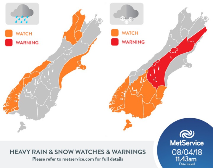
The first heavy snowfall
watches and warnings have been issued for 2018. Check the MetService website for full details and
the latest updates.
 Gordon Campbell: On What’s Wrong With The Treaty Principles Bill
 Ministry For Culture And Heritage: Reverberations Of Erebus Disaster Still Felt 45 Years Later
 Watercare Services: No Cause For Concern After Slightly Elevated Levels Of Arsenic Detected In Treated Waikato River Water
 Te Pāti Māori: Government’s First Year A ‘Catastrophe For Māori’
 Department Of Internal Affairs: Samoan Citizenship Bill Passes Into Law
 NZ National Party: National Acknowledges The Passing Of Hon Nikki Kaye
 Mana Mokopuna: Children And Young People Share Vital Insights On Healing From Family Violence And Sexual Violence In New Report