 Scoop has an Ethical Paywall


MetService: Two Fronts to Move Across the Country
MetService News Release
3 April
2018
Two Fronts to Move Across the Country
This week much of the country remains dry despite a series of fronts travelling northward over the South Island. This means it is set to be a wet few days for those in the west of the South Island, some scattered showers for the west of the North Island, but in contrast most eastern areas of both Islands remain dry.
“There are two significant fronts set to pass over the country this week. The first is currently affecting the South Island and weakens and slows as it passes over the central North Island during Wednesday,” Gerrit Keyser MetService Meteorologist reported.
“By the time it is over the North Island later today (Tuesday), the front will have only a fraction of its original intensity bringing scattered showers, mainly for western regions,” continued Keyser.
A brief ridge of high pressure pushes onto the North Island bringing some finer weather Thursdaybefore another front is forecast to move onto the far south on Friday bringing a similar sequence of weather to New Zealand during Friday and Saturday.
This common weather pattern reflects the basic climatology of New Zealand, as the predominant westerly wind flow over our latitudes paired with a sheltering effect from the Southern Alps means the west coast of the South Island receives, on average, eight times the rainfall from passing troughs compared to the east coast. This is essentially why the western coasts of the South Island are renowned for their lush, green forests.
“All in all, a generally settled week of weather is signalled for the North Island and east of the South Island with plenty of sunshine hours expected, even if the evenings have become shorter with the recent end to daylight saving,” Keyser said.
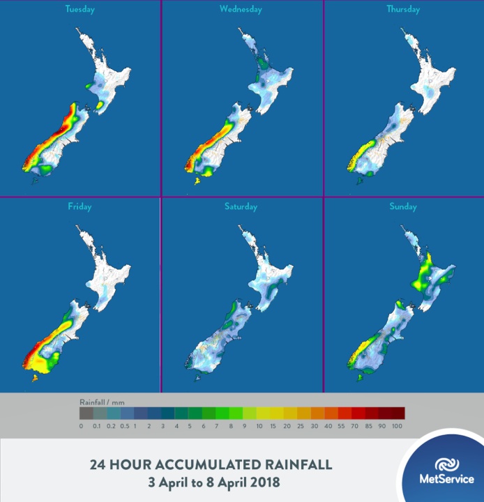
The image above shows the
forecast rainfall accumulations for each day from one of the
global weather models (UKMO).
 Gordon Campbell: On What’s Wrong With The Treaty Principles Bill
 Ministry For Culture And Heritage: Reverberations Of Erebus Disaster Still Felt 45 Years Later
 Watercare Services: No Cause For Concern After Slightly Elevated Levels Of Arsenic Detected In Treated Waikato River Water
 Te Pāti Māori: Government’s First Year A ‘Catastrophe For Māori’
 Department Of Internal Affairs: Samoan Citizenship Bill Passes Into Law
 NZ National Party: National Acknowledges The Passing Of Hon Nikki Kaye
 Mana Mokopuna: Children And Young People Share Vital Insights On Healing From Family Violence And Sexual Violence In New Report