A look back and the forecast ahead
A look back at the week, and the forecast for the week ahead
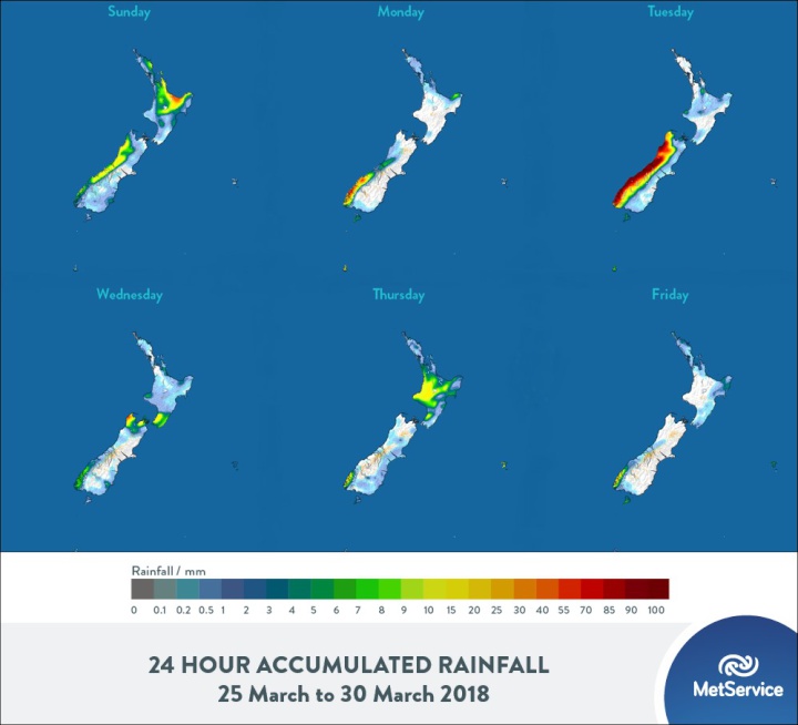
The weather over the country this past week has been dominated by two features. Firstly, a broad ridge of high pressure extended over much of Aotearoa from a dominant area of high pressure southeast of the Chatham Island. This ridge was in place from Sunday 18th through to the Tuesday20th. On Wednesday, the ridge began breaking down as a second feature, an active front moved up the South Island.
MetService meteorologist Andy Best said, “This front brought significant amounts of rain to Fiordland and the West Coast of the South Island, from Monday through to Wednesday, and several Severe Weather Watches and Warnings were issued by MetService linked to this front.” He went on to say, “On Monday, Haast recorded 35mm of rain and 33mm on Wednesday, while Milford Sound recorded 169mm on Monday, 122mm on Tuesday and 15mm on Wednesday.”
The front became very slow moving as it tracked northeastwards as it became blocked by the high to the east. From Wednesday through to Saturday, the front became stationary from Cape Egmont along the West Coast of the South Island. 20mm of rain was recorded at Westport Airport on 23rdand 39mm on the 24th, while Farewell Spit recorded 41mm on the 21st, 22mm on the 22nd and 4mm on the 24th. This front eventually made progress northeastwards to lie over the upper North Island today (Sunday), with severe weather watches for thunderstorms and heavy rain over the eastern Bay of Plenty and the northern ranges of Gisborne.
The forecast for the week ahead brings mainly fine conditions for northern and eastern parts of the North Island out to Wednesday, but turning to showers there Thursday and Friday. The remainder of the North Island can expect mostly fine conditions on Monday, with isolated showers for Tuesday, but rain or drizzle developing from Waikato to Wellington on Wednesday, then clearing from the south on Thursday and becoming mainly fine.
For the South Island, mostly fine on Monday with variable high cloud, but showers for Westland and rain for Fiordland. Rain becoming heavy in the west on Tuesday, with scattered falls for the Canterbury High Country. Mostly fine on Wednesday, apart from a period of rain in the north as well as showers for Fiordland. Thursday and Friday have a similar outlook, with showers for Fiordland but mostly fine conditions elsewhere.


 Gordon Campbell: On What’s Wrong With The Treaty Principles Bill
 Ministry For Culture And Heritage: Reverberations Of Erebus Disaster Still Felt 45 Years Later
 Watercare Services: No Cause For Concern After Slightly Elevated Levels Of Arsenic Detected In Treated Waikato River Water
 Te Pāti Māori: Government’s First Year A ‘Catastrophe For Māori’
 Department Of Internal Affairs: Samoan Citizenship Bill Passes Into Law
 NZ National Party: National Acknowledges The Passing Of Hon Nikki Kaye
 Mana Mokopuna: Children And Young People Share Vital Insights On Healing From Family Violence And Sexual Violence In New Report


