 Scoop has an Ethical Paywall


A weather-laden front impacts the South Island today
A weather-laden front impacts the South Island today and the North Island Monday
Forecasters are currently focusing on an active front moving up the South Island today, bringing strong winds ahead of the front as well as significant falls of rain. The front is forecast to be close to Ashburton around 1am Monday morning and near Palmerston North by 1pm Monday. MetService meteorologist Andy Best said, “The front delivers a period of heavy rain to the west of the South Island and parts of the lower North Island.” He went on to say that “severe northwest gales are forecast for eastern areas of central and southern New Zealand, and there may be a short period of heavy rain about Wellington tomorrow morning on a southerly wind change”. People are advised to keep up to date with the latest forecasts on metservice.com, in case other areas are added to the warnings.”.
The front continues to move north during Monday and Tuesday, and a ridge of high pressure builds over the South Island in the wake of the front. Clearing skies and light winds associated with the ridge will bring cooler temperatures than of late. For example, Alexandra’s minimum temperature is expected to be 6C overnight Monday/Tuesday and Dunedin sees a maximum of 25C expected today, dropping to a maximum of just 15C on Monday. Christchurch can expect a maximum of 26C today thanks to the strong northwesterlies, with a high of only 17C on Tuesday.
The ridge is expected to drift eastwards towards the Chatham Islands on Wednesday and Thursday, leaving New Zealand under a northeast airstream. Looking ahead, Wednesday brings cloudy conditions for most of the North Island, with a few showers in the north and west, and isolated showers elsewhere. The majority of the South Island stays mainly fine with rain developing in the north. The outlook for Thursday, showers for most of the North Island, mainly fine with increasing high cloud in the east of the South Island, but rain elsewhere, possibly heavy in Westland and Fiordland.
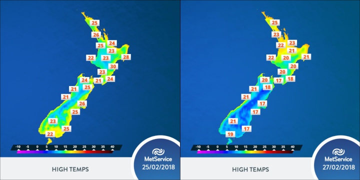
Comparison
between Sunday’s and Tuesday’s maximum
temperatures
 Gordon Campbell: On What’s Wrong With The Treaty Principles Bill
 Ministry For Culture And Heritage: Reverberations Of Erebus Disaster Still Felt 45 Years Later
 Watercare Services: No Cause For Concern After Slightly Elevated Levels Of Arsenic Detected In Treated Waikato River Water
 Te Pāti Māori: Government’s First Year A ‘Catastrophe For Māori’
 Department Of Internal Affairs: Samoan Citizenship Bill Passes Into Law
 NZ National Party: National Acknowledges The Passing Of Hon Nikki Kaye
 Mana Mokopuna: Children And Young People Share Vital Insights On Healing From Family Violence And Sexual Violence In New Report