MetService: Wet And Humid Weekend For Most
Wet And Humid Weekend For Most
The mostly-settled weather we’re currently enjoying is expected to come to an end this weekend as a ridge of high pressure starts to give way to a moist, strong easterly flow. A band of rain associated with a broad area of low pressure from the Tropics has started sinking south over the upper North Island. By the end of the weekend most of the country will see some wet weather, with the only exception being the southern part of the South Island which will remain mostly dry.
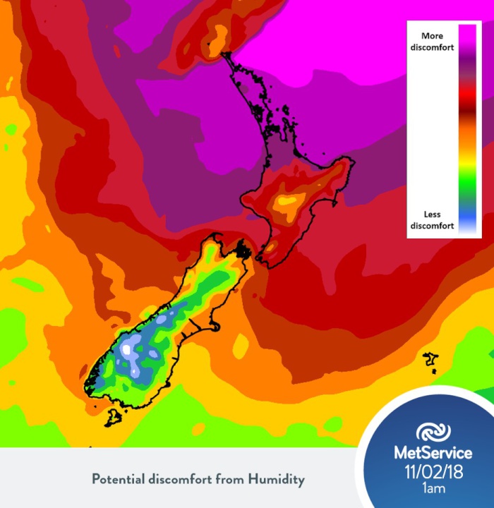
As the humid air mass tracks over the North Island during the weekend, uncomfortably warm overnight temperatures will return for most.
MetService meteorologist Kyle Lee said, “Temperatures in North Island main centres aren’t expected to drop below 18C this weekend, with all the main centres seeing above-average minimum temperatures.”
“Although the South Island won’t be as warm, most centres will still be above their average minimum temperatures for this time of year,” Lee added.

How much the humidity
will affect the overnight temperatures on Sunday at
1am.
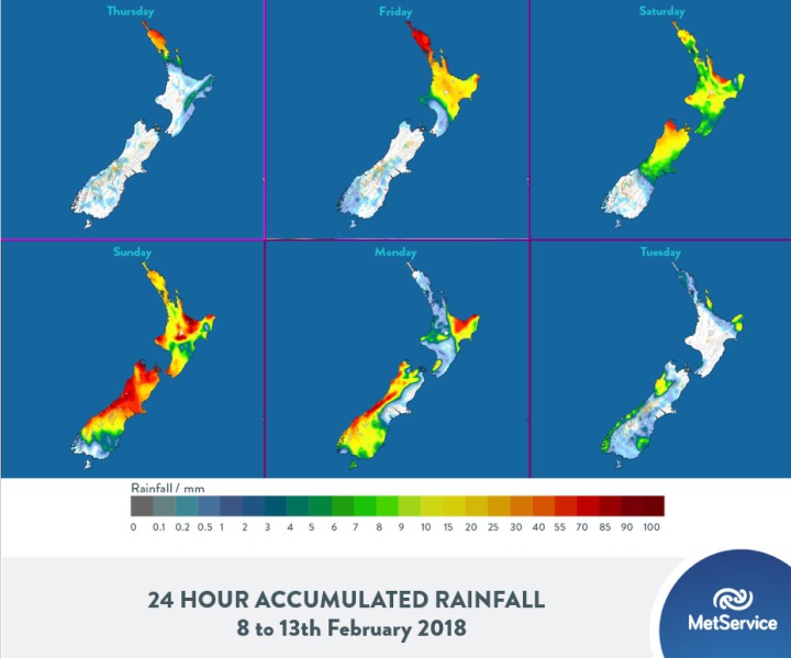
Of more concern for this weekend will be heavy rainfall, which could affect parts of the country still recovering from the damage caused by last week’s severe weather event.
Lee commented, “We currently have a Severe Weather Warning in force for heavy rainfall in Northland, and Watches for Auckland and the Coromandel Peninsula. Other areas which could see heavy rain during this weather event are Bay of Plenty, northern Gisborne, Taranaki, Nelson and the west coast of the South Island.”
MetService’s Monthly Outlook shows wetter-than-average conditions expected for the North Island, with warm and muggy temperatures lingering. The Tropics are also quite active right now; although we have seen only one named system so far this Tropical Cyclone season, there is the potential for a few more storms to brew in the coming weeks. You can find out more about MetService’s role in monitoring the tropics at http://info.metraweather.com/e/60812/ings-tropical-cyclone-activity/fnc13h/665555154.

Accumulated rainfall
expected over New Zealand for the next 6
days.
Official Severe Weather Watches and Warnings are reviewed and re-issued by MetService at least every twelve hours, and more often if necessary. To get the most up to date information on severe weather around the country, or any other forecasts, see metservice.com or on mobile devices at m.metservice.com. You can also follow our updates on MetService TV, at MetService New Zealand on Facebook, @metservice and @MetServiceWARN on Twitter and at blog.metservice.com
MetService
issues Warnings, Watches and Outlooks for severe weather
over New Zealand.
Warnings are about
taking action when severe weather is imminent or is
occurring. They are issued only when required.
Recommendation: ACT
Watches
are about being alert when severe weather is
possible, but not sufficiently imminent or certain for a
Warning to be issued. They are issued only when required.
Recommendation: BE READY
Outlooks
are about looking ahead, providing advance
information on possible future Watches and/or Warnings. They
are issued routinely once or twice a day.
Recommendation: PLAN


 Gordon Campbell: On What’s Wrong With The Treaty Principles Bill
 Ministry For Culture And Heritage: Reverberations Of Erebus Disaster Still Felt 45 Years Later
 Watercare Services: No Cause For Concern After Slightly Elevated Levels Of Arsenic Detected In Treated Waikato River Water
 Te Pāti Māori: Government’s First Year A ‘Catastrophe For Māori’
 Department Of Internal Affairs: Samoan Citizenship Bill Passes Into Law
 NZ National Party: National Acknowledges The Passing Of Hon Nikki Kaye
 Mana Mokopuna: Children And Young People Share Vital Insights On Healing From Family Violence And Sexual Violence In New Report


