 Scoop has an Ethical Paywall


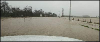
Flooding Otago, South Island highways 10.30 am
Flooding Otago, South Island highways 10.30 am
– avoid travel
People are advised to avoid travel on highways and roads of Otago and Canterbury, south of Christchurch, today with highways closed all over Otago and parts of State Highway 1 closed south of Christchurch with the Selwyn River overtopping its banks thismorning.
• SH1 north of Dunedin to
Oamaru remains closed.
• Due to rising levels on
the Selwyn River, State Highway 1, this morning has been
closed at Telegraph Road, south of Rolleston through to
Rakaia. A detour is in place via Telegraph Road, to Darfield
State Highway 77(as far as Methven) and Inland Route 72 if
essential travel is required. (Methven to Ashburton is still
closed.)
• Access between Ashburton and Rakaia
is expected to open soon for essential travel. Please be
prepared for delays, many roads are affected by surface
flooding.
• See this site for details on Canterbury
river levels. https://www.ecan.govt.nz/home/flood-warning/.
Selwyn River flows here.
No flooding signs does
not mean no danger at highways and fords
Please
be aware that contractors have run out of flooding signs in
many places, so people need to be aware that fords may be
deeper than they think. Drive with caution advises Civil
Defence Emergency Management in Otago. “Not every area
with surface flooding is signposted.”
Passing lanes at Dunsandel today south of Christchurch, south of the Selwyn River:
For Otago updates,
please go to the Civil Defence and Emergency management
pagehere or their Facebook page:
http://www.otagocdem.govt.nz/major-incident/july-flood
https://www.facebook.com/OtagoCDEM/
Dunedin City Council’s flooding updates here and on Facebook.
https://www.facebook.com/DnEmergency/
http://otagocdem.govt.nz/districts/dunedin
Otago
•
SH8 Lindis Pass Road Open – Restrictions, Snow,
Chains to be carried.
• NEW: SH 6 Ross
To Haast - High Winds- Care required by caravans,
campervans, motorcycles and other high sided vehicle.
•
SH1 Balclutha to Clarkesville - Flooding - ROAD
CLOSED
• SH8 Raes Junction to Milton - Flooding
- ROAD CLOSED
• SH90 Raes Junction to Mcnab -
Flooding - ROAD CLOSED
• SH88 Maia to Sawyers
Bay - Flooding - ROAD CLOSED
• SH8 Roxburgh to
Raes Junction - Flooding - ROAD CLOSED
• SH87
Kyeburn to Outram - Flooding - ROAD CLOSED
• SH1
Oamaru to Waikouaiti - Flooding - ROAD CLOSED
•
SH85 Palmerston to Omakau - Flooding - ROAD CLOSED
•
SH 83 Pukeuri To Omarama - Flooding - ROAD CLOSED
•
SH 1 Pukeuri To Redruth - Flooding - ROAD CLOSED
•
SH 1 East Taieri To Clarksville - Flooding
•
SH 87 Mosgiel To Outram - Surface Water - Road users are
advised to take extra care.
• SH 1 Waikouaiti To
Waitati - Surface Water - Road users are advised to take
extra care.
• SH 8 Raes Junction To Alexandra -
Flooding
• SH 6 Haast To Hawea - Strong Winds -
Extra care required, especially for high sided vehicles and
motorcycles.
Southland
• SH 94
Mirror Lakes To Gulliver River Bridge - Strong Winds - Care
required by caravans, campervans, high sided vehicles and
motorbikes, especially in alpine areas.
Canterbury (Including alpine / mountain
passes)
• SH7 Lewis Pass - Road is now
OPEN.
• SH82 Waimate to Kurow - Flooding - ROAD
CLOSED
• SH79 Fairlie to Geraldine - Flooding -
ROAD CLOSED
• SH1 Dunsandel to Ashburton -
Flooding - ROAD CLOSED
• SH77 Ashburton to
Methven - Flooding - morning - ROAD CLOSED
• SH1
Rakaia to Ashburton, Road Closed, Flooding
• SH1
Rolleston to Rakaia, Road Closed, Flooding
• SH8
Lindis Pass Road Open – Restrictions, Snow, Chains to be
carried.
South
Canterbury
• Transport Agency
contracting crews are assessing many roads around Timaru
currently with river levels receding there. They hope to
reopen SH1 Rakaia to Timaru this morning
(Saturday).
Kaikoura
access
• The southern State Highway 1
route to Kaikoura via the Hundalees and Cheviot is open, but
drivers will be convoyed between Peketa and Goose Bay. The
highway closes at 6 pm Saturdaynight, open normally 7 am to
6 pm Friday to Monday inclusive.
• The inland road, Route 70 via Waiau, remains closed until midday at least Saturday at this point with road crews clearing debris and small slips from daybreak. Please note, even when this road is closed to Kaikoura, it is open to Mt Lyford for people staying in the alpine village.
How to stay up to
date:
• www.nzta.govt.nz/traffic
•
Important information is also shared via the Transport
Agency’s official Twitter and Facebook accounts listed
here https://www.nzta.govt.nz/contact-us/connect-with-us/
•
Find safe winter driving tips at www.nzta.govt.nz/winterjourneys
• Drivers can also call 0800 4 HIGHWAYS (0800
44 44 49) to speak to the call centre team who can provide
them with traffic and travel information either before
they’re travelling or when they’re on the road, safely
parked off the highway.
• MetService severe
weather warnings here.
• Keep up to date with
the latest MetService forecasts and any watches/warnings at
metservice.com or on mobile devices at
m.metservice.com.
 Gordon Campbell: On What’s Wrong With The Treaty Principles Bill
 Ministry For Culture And Heritage: Reverberations Of Erebus Disaster Still Felt 45 Years Later
 Watercare Services: No Cause For Concern After Slightly Elevated Levels Of Arsenic Detected In Treated Waikato River Water
 Te Pāti Māori: Government’s First Year A ‘Catastrophe For Māori’
 Department Of Internal Affairs: Samoan Citizenship Bill Passes Into Law
 NZ National Party: National Acknowledges The Passing Of Hon Nikki Kaye
 Mana Mokopuna: Children And Young People Share Vital Insights On Healing From Family Violence And Sexual Violence In New Report