 Scoop has an Ethical Paywall


Rangitikei River Land Slip Affecting River Flows
Wednesday 18 January 2017
Rangitikei River Land Slip Affecting River Flows
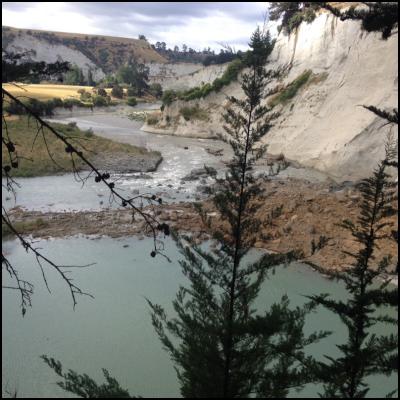
Horizons Regional Council received a phone call from a member of the public at 6.40am this morning, to alert our emergency response team of a significant slip in the Rangitikei River south of Mangaweka. This slip appears to have initially blocked the entire river channel.
Horizons Regional Council Emergency Operation Centre controller Craig Grant says a visual assessment of the area has been carried out by council staff, along with a review of catchment data information for normal flows in this part of the river.
“Following our assessment of the site, we have determined that while the slip is predominately covering the river’s width, the water has already cut a 10 metre wide path to allow water through,” says Mr Craig.
“We have no immediate concerns of this slip building up a wall of water or breaching the natural dam, and therefore advice there is no current concern for public safety.
“However, anyone downstream of the site is asked to be aware of changes to both flow and clarity of the river over the next few days.
“We will continue to monitor the situation, but predict the slip will eventually erode itself away as part of its natural course.
“This area is a beautiful part of our Region, and is particularly popular for camping and swimming.
“Rivers can be unpredictable, and slips such as this one can occur often. We would like to remind people that before they enter the water to always check for strong or unusual currents, hidden hazards, and potentially dangerous banks and cliffs.
For anybody who notices a potential hazard in our waterways are asked to ring Horizons’ hotline on 0508 800 800.
Ends
 Gordon Campbell: On The Hikoi Aftermath
 Infrastructure New Zealand: Single Agency Needed To Coordinate Climate Adaptation And Recovery
 Free Speech Union: Fair Digital News Bargaining Bill Likely To Restrict Access To Information, Polling Shows Most Oppose
 Auckland Transport: Driver Safety Screens Now Rolling Out Across Auckland’s Bus Fleet
 People Against Prisons Aotearoa: 'Expect Resistance' - Community Group Pushes Back Against More Cops With Guns
 Greenpeace: New Zealand Drops In Global Ranking On Climate Action
 PSA: Spending Cuts Need To Stop - PSA Urges Govt To Listen To Economists