 Scoop has an Ethical Paywall


New track to detour around Dart Valley lake and landslide
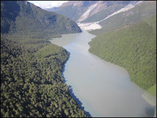
The landslide and new lake in the Dart Valley. The track detour will traverse the dense bush and steep slopes on the eastern (true left) side of the lake.
Media release
Date: 13th January 2014
New track to detour around Dart Valley lake and landslide
Walking access through the Dart Valley is set to be reinstated by the end of January. After several visits to the area DOC Rangers have now completed their survey of a new route around the large lake and massive landslide that blocked the track on the 4th January.
Senior Conservation Services Ranger Richard Kennett confirms “We have identified an alternative route for trampers that will take them safely past the affected area. A new track will now sidle above the recently formed lake on its eastern (true left) side, before leading trampers to the usual track over Sandy Bluff. After this point the track will then descend to the eastern (true left) bank of the river. More changes will be required here when the landslide has forced the river to erode the bank and undercut the track. As the realigned track will remain on the true left of the Dart River, the landslide debris will be avoided altogether.”
Richard warns “at first this new track will be a very basic route. While we will endeavour to clear the vegetation it will be very rough and muddy underfoot. It will not be passable in wet weather as it crosses several streams that will quickly flood during heavy rain, becoming hazardous for trampers to cross”. Richard estimates the roughness of the track will add 1-2 hours to the standard walking time between Daleys Flat Hut and Chinamans Bluff (usually 3.5 to 5.5 hours).
Work for the track realignment will commence shortly and is expected to take up to two weeks to complete. Until the new track is completed the Dart Valley Track between Bedford Stream and Daleys Flat Hut remains closed. Work could be delayed by weather or conditions on the ground and DOC will make a further announcement when the new track is to be opened. DOC will then monitor conditions on the new route for the remainder of the summer before seeking to make improvements during the winter months.
The Dart Valley landslide has formed within an existing zone of instability located in the Te Koroka / Slip Stream area. This zone has been depositing fresh material into the valley for over a year however recent rainstorms have led to the much larger landslide on January 4th. Further rain will continue to deliver more material into the valley. GNS considers the landslide-related debris flows and the resultant lake pose no additional hazard on the lower Dart River below the dam.
The Rees/Dart track is a popular 4 to 5 day circuit in the Mt Aspiring National Park. The circuit received about 2,000 overnight trampers per year. A further 3,000 people per year undertake a shorter day walk from either the Rees Valley or Dart Valley road end.
ENDS
 Gordon Campbell: On Abortion’s Role In The US Election
 Department of Conservation: Priority Conservation Projects Open For Donations
 NZ Labour Party: Winston Peters Must Apologise
 Meat The Need: National Charity Auction To Combat Food Insecurity In New Zealand
 Inland Revenue Department: Inland Revenue Stops Using Custom Audience Lists
 Horowhenua District Council: Foxton War Memorial Hall Finds A New Life In Community Hands
 Council for International Development: CID & Members’ Call For Action Against UNRWA Ban In Israel And Occupied Palestinian Territories