 Scoop has an Ethical Paywall


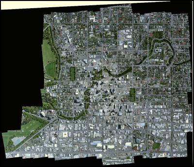
UC captures CBD aerial images for CERA in the rebuild
UC captures CBD aerial images for CERA in the rebuild
December 5, 2012
The University of Canterbury (UC) has been helping the Christchurch Earthquake Recovery Authority (CERA) in Christchurch by providing aerial images of the central business district (CBD) area for future planning.
UC’s Spatial Engineering Research Centre (SERC) was approached by CERA to take some aerial mapping photos of the CBD.
``CERA wanted to help visualise the current state of demolition and to assist in the planning of the new city,’’ UC’s SERC senior research engineer Kelvin Barnsdale said today.
``As we have a purpose-built aerial photography package, we offered to do much more than take some snaps. We recently took to the sky and covered the area of the four avenues in 12cm resolution aerial photographs.
``The mission went flawlessly, and after the flight over two hundred photographs were stitched together by the SERC’s photogrammetry software.
``The final image was so impressive SERC made it into a large poster which is now being purchased by Shirley Boys and Burnside High Schools. They ordered multiple copies for their geography and social studies classes and Shirley Boys requested we present a lesson on aerial photography to their students.
Barnsdale said they hoped to work further with CERA at regular intervals to provide fully updated images of the whole CBD as the rebuild advances and Christchurch becomes a new city.
The photos were taken from a light aircraft piloted by a former Air New Zealand 747 pilot who has his own airstrip near the city.
The aerial mapping package was built by SERC three years ago at a cost of around $100,000.
Barnsdale said the aerial mapping package was very adaptable and can include still shot cameras as well as high definition video equipment. It also carries a thermal infrared camera, which is where UC’s research interests really lie.
``Our pilot and his plane are not a commercial business. He supplies his time to the Spatial Engineering Research Centre free of charge. The data we collect is for research purposes only and to train students in the process of aerial photography.
``This aerial photo packaging has the advantages of being quickly deployable and low cost, as well as flexible in the types of camera it can carry.’’
In 2009, SERC surveyed all of Christchurch recording thermal images for the Christchurch City Council to find out roofing temperatures.
ends
 Gordon Campbell: On The Trump Upside, And Peters Persecution Of Trans People
 New Zealand Defence Force: Second World War Veterans Receive Message From King Charles
 New Zealand Government: More Than 900 Health Graduates To Receive Financial Boost Through Bonding Scheme
 New Zealand Police: Stacks Of Cocaine Unpacked In Mt Wellington
 Te Pāti Māori: Te Pāti Māori Make Submission To Privileges Committee In Absentia
 PSA: PSA Forces Changes To Restructure Of Data & Digital And Pacific Health
 Waitangi Treaty Grounds: Anzac Day Commemorative Evening Service At The Waitangi Treaty Grounds