Landcare Research staff map extent of storm damage
Landcare Research staff map extent of storm damage
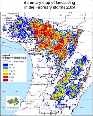
The recent February storm in the lower North Island produced severe and widespread landsliding.

The landsliding extent has been mapped by Landcare Research staff at the Palmerston North office using the French SPOT5 satellite. 19,800 hectares of land has been lost to pasture production, either through erosion or deposition of debris.
The worst affected district was the Rangitikei (6,300 ha), followed by the Manawatu district (4,500 ha) and the Wanganui district (4,100 ha).
Erosion scars, which comprise approximately 25% of the total, can take up to 10 years to regain productivity. Debris tails, which comprise approximately 75% of the total, can regain pasture productivity with one year.


 Gordon Campbell: Gordon Campbell On The Folly Of Making Apologies In A Social Vacuum.
 Wai Ako Books: Best-Selling Author & Lawyer Creates Free Easy Tool To Help Kiwis Oppose Controversial Treaty Bill
 Asians Supporting Tino Rangatiratanga: Asian Communities From Across Aotearoa Join Hīkoi Mō Te Tiriti
 Cooper Legal: Censorship Is Alive And Well In New Zealand
 NZ Government: NZ Signs Trade Deal With Costa Rica, Iceland And Switzerland
 Forest And Bird: Modernisation Of Conservation System Must Focus On Improving Conservation
 NZCTU: Uniformed Defence Force Should Not Be Used As Strike Breakers


