 Scoop has an Ethical Paywall


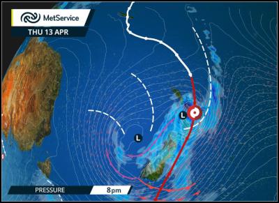
Following the movemet of Cyclone Cook
MetService News Release
13 April 2017
Cyclone Cook
Cyclone Cook has arrived in New Zealand coastal waters this morning and MetService is following its movement very closely. Widespread rain continues over large parts of the country, although the heaviest and most significant falls remain closely wrapped around the low centre. MetService’s rain radar indicates that this area contains very heavy rainfall, which is expected to move onto Coromandel Peninsula and Bay of Plenty from this afternoon ahead of the low centre this evening.
At the same time, damaging severe gales will accompany the low centre with wind gusts of 150km/h or more possible. In addition, swell of five metres or more is expected with this event in the northeast of the North Island, before heading to the south coast of the North Island tonight, and when you add this to the strong winds we can expect very high waves. Sea conditions will be dangerous and large waves may lead to coastal inundation and erosion.
“Cyclone Cook is set to track southwards at a fast pace, bringing severe weather further south while clearing from the north and leaving more settled weather in its wake,” said Meteorologist Arno Dyason, “The low centre is expected to sit over the lower North Island late tonight or early Fridaymorning, then track just offshore down the east of the South Island for the remainder of Friday.”
Most regions remain under a Severe Weather Watch or Warning during today and tomorrow as heavy rainfall and strong winds are also expected further away from the centre of the cyclone.
“Cyclone Cook’s arrival in New Zealand is a very significant event due to the severity of the storm and people are advised to take extreme care,” said Mr Dyason, “People should prepare for the possibility of flooding, landslips, wind damage to powerlines, property and large trees. People should be prepared to change their travel plans if necessary as driving could become hazardous during the severe weather period. “
Cyclone Cook making landfall
onto Bay of Plenty this evening, then moving further
south.
Official Severe Weather Watches and Warnings are reviewed and re-issued by MetService at least every twelve hours, and more often if necessary. To get the most up to date information on severe weather around the country, or any other forecasts, see metservice.com or on mobile devices at m.metservice.com. You can also follow our updates on MetService TV, at MetService New Zealand on Facebook, @metservice and @MetServiceWARN on Twitter and at blog.metservice.com
 Plumbers Gasfitters and Drainlayers Board: Plumbers, Gasfitters And Drainlayers Board Drops ‘Journeyman’ And ‘Tradesman’ Names
 ERANZ: Electricity Saving Coaching Service To Launch In Wairoa
 SolarZero Affected Staff: SolarZero Staff Are Demanding Answers After The Company Went Into Liquidation
 Tātau Tātau O Te Wairoa: Guidance To Save Local Newspapers Amid NZME Closures
 Commerce Commission: Systemic Breaches Of Consumer Law Lead To $1.5million Fine For Kiwibank
 SolarZero: SolarZero Limited (in Liquidation) - Important Business Update


