Here comes the rain again
MetService News
Release
Tuesday 11 April
2017
Here comes the rain again
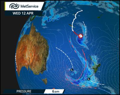
For the second week in a row, heavy rain, thunderstorms, strong winds and large swells are set to affect much of New Zealand. This time round, the northeasterly flow ahead of a Low in the Tasman Sea is dragging a lot of humid, sub-tropical air down across New Zealand. Warm air can hold more moisture, so we’re expecting heavy rain – especially for the West Coast of the South Island, Otago, and much of the North Island.
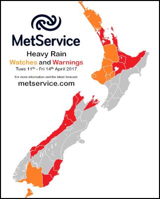
On Wednesday, thunderstorms with downpours of up to 40mm in an hour are expected to affect the upper North Island north of a line from Taranaki to the Bay of Plenty. There are numerous Severe Weather Watches and Warnings in place and these will be updated throughout this event.
“Many regions are already waterlogged; to make things worse, some of these areas are about to get more heavy rain,” explained MetService Meteorologist Lisa Murray. “Severe Weather Watches and Warnings will be updated as soon as any new information is available, so make sure you check our website regularly for the latest information.”
Meanwhile, Tropical Cyclone Cook is currently south of New Caledonia and expected to track south-southeast. As it passes latitude 25 degrees south, Cook will move into MetService’s area of responsibility as the official Tropical Cyclone Warning Centre for this region (more information about the Wellington Tropical Cyclone Warning Centre can be found on our website: Tropical Cyclone Monitoring). Tropical Cyclone Cook is then expected to transition into a mid-latitude low, remaining a significant weather system with strong winds and heavy rain. You can read more about extra tropical cyclones at this blog: Tropical cyclones: extra-tropical transition. Tropical Cyclone Cook will then become simply “Cyclone Cook” and, although it will no longer be a TC, it could still bring damaging winds, heavy rain and significant storm surge for those exposed to the onshore flow.
However, before Cyclone Cook nears us, the Tasman Sea Low will bring heavy rain to New Zealand, along with the potential for flooding for the upper North Island in particular. Cyclone Cook may then prolong the rainfall in some of the already-affected areas. The Bay of Plenty is expected to get the largest rainfall totals, with 200 - 250mm expected to fall over 48 hours. These kinds of rainfall totals will have significant impacts in already waterlogged areas – and Cook has the potential to add to this.
Cyclone Cook may also bring severe gales to parts of the North Island. However, there is still some uncertainty regarding the track of the Cyclone, and this will influence which areas see the worst of the winds at the end of the week. Again, MetService Warnings and Watches will keep the public and emergency management up to date with potential areas of impact.
“Before you head off on your Easter break it will be especially important to check the latest weather forecast, Watches and Warnings, as well as checking the NZTA website for any heavy traffic or road closures,” advises Murray. “If the weather is bad, it might be worth postponing travel until the weather passes.”

The low in the Tasman Sea
causes several fronts to cross New Zealand, bringing heavy
rain. Further North, Tropical Cyclone Cook is beginning to
move southwards.

Watches and Warnings have
already been issued for many parts of the country, and will
be updated at least every twelve hours as the event
unfolds.


 Gordon Campbell: On The Royal Commission’s Fine-tuning Of Vaccine Mandates And Lockdowns
 NZDF: Details From Interim Court Of Inquiry Report Into HMNZS Manawanui Incident Released
 Land Air Water Aotearoa: Ambitious Nationwide Initiative To Track And Share Actions To Improve Freshwater
 NZ Government: Chemical Weapons And Iranian Missiles Targeted In New Russia Sanctions
 Ministry For Culture And Heritage: Reverberations Of Erebus Disaster Still Felt 45 Years Later
 Watercare Services: No Cause For Concern After Slightly Elevated Levels Of Arsenic Detected In Treated Waikato River Water
 Te Pāti Māori: Government’s First Year A ‘Catastrophe For Māori’


