A respite before northerlies and rain return
MetService News Release
30 March 2017
A respite before northerlies and rain return
The fog may have lifted and the heavy rain eased, but moist northerlies are poised to return by early next week after a ridge of high pressure brings a period of settled weather to our shores.
On Wednesday, heavy rain washed out the final day of the cricket test in Hamilton and caused localised flash flooding in parts of Auckland. Further south, fog delayed flights in and out of Wellington, affecting thousands of travellers. MetService Meteorologist Peter Little commented, “An area of low pressure responsible for the heavy rain also pushed moist air down the east coast of the North Island, which turned to fog as it moved over the relatively cooler seas around Wellington.”
As the low moves away to the east it is replaced by a ridge of high pressure, which ensures that most places have a sunny end to the week. “However, the air over the country remains humid, meaning further muggy nights in the north, and areas of low cloud and fog morning and night,” added Little.
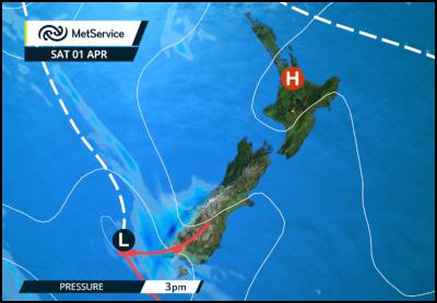
As we head into the final weekend of daylight saving there is a mixture of fine and wet weather on the horizon. A front from the South Tasman Sea approaches the South Island on Saturday, bringing rain to Fiordland and South Westland. As the front moves up the South Island on Sundaythe rain spreads further north, and scattered falls are expected east of the Alps.
For the North Island, aside from some morning cloud in northern and western areas, predominantly fine weather is forecast on Saturday. This will please those competing in the IronMaori multi-sport event in Auckland, along with their supporters. The weather remains fine in the east of the North Island on Sunday, but increasing moisture elsewhere brings mostly cloudy skies with patchy rain or drizzle.

Forecast mean sea level
pressure and fronts from Weatherscape
Early next week, tropical moisture associated with former Cyclone Debbie is expected to be drawn down over northern and central New Zealand. Little went on to say, “Although Debbie is no longer a Tropical Cyclone, and is not expected to cross the Tasman, warm and moist tropical air will likely spread onto New Zealand ahead of a frontal system early next week. This injection of extra moisture will increase the potential for heavy rain and localised downpours over parts of central and northern New Zealand, which are still sodden from recent heavy rain. People in these areas are advised to keep up to date with forecasts, and view the Severe Weather Outlook which can be found on our warnings home page http://info.metraweather.com/e/60812/AllWarnings/clnpyq/518756495.”
Official Severe Weather Watches and Warnings are reviewed and re-issued by MetService at least every twelve hours, and more often if necessary. To get the most up to date information on severe weather around the country, or any other forecasts, see metservice.com or on mobile devices at m.metservice.com. You can also follow our updates on MetService TV, at MetService New Zealand on Facebook, @metservice and @MetServiceWARN on Twitter and at blog.metservice.com


 Gordon Campbell: On The Royal Commission’s Fine-tuning Of Vaccine Mandates And Lockdowns
 NZDF: Details From Interim Court Of Inquiry Report Into HMNZS Manawanui Incident Released
 Land Air Water Aotearoa: Ambitious Nationwide Initiative To Track And Share Actions To Improve Freshwater
 NZ Government: Chemical Weapons And Iranian Missiles Targeted In New Russia Sanctions
 Ministry For Culture And Heritage: Reverberations Of Erebus Disaster Still Felt 45 Years Later
 Watercare Services: No Cause For Concern After Slightly Elevated Levels Of Arsenic Detected In Treated Waikato River Water
 Te Pāti Māori: Government’s First Year A ‘Catastrophe For Māori’


