A mixed bag of weather for the Equinox
MetService News Release
Monday 20th March
2017
A mixed bag of weather for the Equinox
The Autumnal Equinox occurs at 11:28pm tonight, which means that days and nights are approximately 12 hours each in length, though days are getting shorter very quickly. The weather for the Equinox is a bit of a mixed bag, with a westerly flow sitting over the country. This is bringing areas of cloud, particularly to western places, and the odd shower. Those in Otago and Southland will be affected by a cold front that gradually moves northwards today, bringing a few showers, strong or gale southwesterlies, and a drop in temperatures.
“It looks like it is going to be quite a mixture of weather for most people this week,” said MetService Meteorologist Claire Flynn. “The westerly flow continues over the North Island on Tuesday and Wednesday, bringing settled weather for most. For the South Island, the West Coast will see a period of rain on Tuesday, while a northeasterly flow develops along the east coast bringing patchy drizzle, which continues on Wednesday.”
On Thursday, a low from the Tasman Sea begins to approach New Zealand, bringing scattered rain across the country by the end of the week. The low is then expected to cross New Zealand during the weekend.
“There is still some uncertainty regarding the position of this low which will affect the weather for many New Zealanders, so make sure you check your forecast for any updates later in the week,” Flynn advised. “The low is expected to bring scattered rain across the country by Friday, though there is just a chance of a shower during Adele’s Thursday night concert in Auckland.”

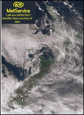
A westerly flow over New
Zealand brings areas of cloud today, mainly in the west. In
the south, you can see several parallel lines of cloud east
of the Alps. This is wave cloud, caused by gale westerly
winds moving over the Alps. Head to http://info.metraweather.com/e/60812/SWWatch/cjmclx/513843657
to read the Severe Weather Watch for gale westerlies in the
far south until Monday evening.
Official Severe
Weather Watches and Warnings are reviewed and re-issued by
MetService at least every twelve hours, and more often if
necessary. To get the most up to date information on severe
weather around the country, or any other forecasts, see metservice.com or on mobile devices at
m.metservice.com. You can also follow
our updates on MetService TV, at MetService New Zealand on Facebook, @metservice and @MetServiceWARN on Twitter and at blog.metservice.com


 Gordon Campbell: On The Royal Commission’s Fine-tuning Of Vaccine Mandates And Lockdowns
 NZDF: Details From Interim Court Of Inquiry Report Into HMNZS Manawanui Incident Released
 Land Air Water Aotearoa: Ambitious Nationwide Initiative To Track And Share Actions To Improve Freshwater
 NZ Government: Chemical Weapons And Iranian Missiles Targeted In New Russia Sanctions
 Ministry For Culture And Heritage: Reverberations Of Erebus Disaster Still Felt 45 Years Later
 Watercare Services: No Cause For Concern After Slightly Elevated Levels Of Arsenic Detected In Treated Waikato River Water
 Te Pāti Māori: Government’s First Year A ‘Catastrophe For Māori’


