Waitangi weekend a highlight in a below-par summer
MetService News Release
2 February
2017
Waitangi weekend a highlight in a below-par summer
There is a sharp dichotomy of opinion this summer – those who need some rain and those who want a break from it. Today should please some of the first group, as scattered rain spreads into parts of Hawkes Bay, while the long weekend should please the latter. There is even a brief reprise for everyone from the persistent winds over southern and central New Zealand on Saturday, although these return later on Sunday.
Today a stalled front is bringing heavy rain to western parts of the North Island, with 50 to 80mm possible in low-lying areas of Horowhenua, Kapiti and northern Taranaki by 3am Friday, with up to 180mm possible in the ranges.
“Guns N’Roses fans will require a little patience with some rain about the capital tonight, although it won’t be as bad as up the coast with ample opportunities to live and let dry,” said meteorologist Tom Adams. “This February rain also spreads across to the parched east, bringing welcome scattered showers to Hawkes Bay, although these falls will hopefully fit in with the cricket and have little appetite for disruption,” he added.
No significant rain is expected to reach equally dry Northland, but the calm and dry weather will be good for those commemorating the signing of Te Tiriti o Waitangi on Monday. On Friday the rain further south eases, and cloud gradually breaks up for a fine long weekend.
A front tries to crash the party on Saturday, bringing a spell of rain to the South Island West Coast. However, our estranged high pressure finally sinks south and eases the rain in the afternoon, while ensuring a dry day for the rest of the country. Sunday will be mostly fine too, although once again we say ‘welcome to the jetstream’ as northwesterlies become strong over the South Island, and a front nears New Zealand with the chance of some night rain in the far south.
Monday should also be dry for most, although the northwesterlies spread up over the North Island, bringing some hot temperatures to Hawkes Bay. It could be fine in the Paradise City of Wellington at first, but cloud quickly builds with the chance of some late drizzle. Anything goes in the South Island, with heavy rain on the West Coast, and a mix of sun and showers in the east.

Click for big version.
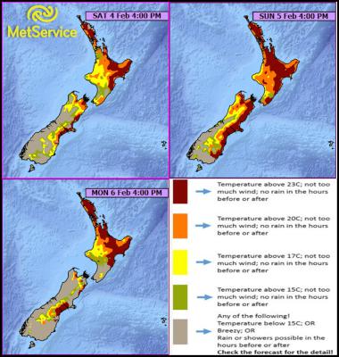
The BBQ index shows ample opportunities for getting outside this weekend.
Official Severe Weather Watches and Warnings are reviewed and re-issued by MetService at least every twelve hours, and more often if necessary. To get the most up to date information on severe weather around the country, or any other forecasts, see metservice.com or on mobile devices at m.metservice.com. You can also follow our updates on MetService TV, at MetService New Zealand on Facebook, @metservice and @MetServiceWARN on Twitter and at blog.metservice.com


 Gordon Campbell: On The Royal Commission’s Fine-tuning Of Vaccine Mandates And Lockdowns
 NZDF: Details From Interim Court Of Inquiry Report Into HMNZS Manawanui Incident Released
 Land Air Water Aotearoa: Ambitious Nationwide Initiative To Track And Share Actions To Improve Freshwater
 NZ Government: Chemical Weapons And Iranian Missiles Targeted In New Russia Sanctions
 Ministry For Culture And Heritage: Reverberations Of Erebus Disaster Still Felt 45 Years Later
 Watercare Services: No Cause For Concern After Slightly Elevated Levels Of Arsenic Detected In Treated Waikato River Water
 Te Pāti Māori: Government’s First Year A ‘Catastrophe For Māori’


